Home
States
Colorado
Connecticut
Maine
Massachusetts
New Hampshire
New York
Rhode Island
Utah
Vermont
View All
Lists
NE 4,000 Footers
NE 100 Highest
NH 4,000 Footers
NH 100 Highest
NH 52 With A View
NH Belknap Range
NH Ossipee 10
Links
Trail Conditions
Trip Log
Sunrises
Sunsets
About
|
Mt. Equinox
Manchester, VT
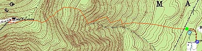
Trailheads, measurements, times, distances, and maps are all approximate and relative to the hike(s) as shown below. "Summit" photos may in fact not be at the actual summit - but instead at the best nearby vista.
Blue Summit trail
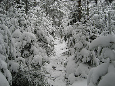
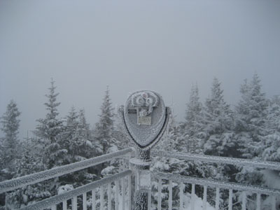
The hike started out as a brisk fall day. After a few hundred vertical feet into the ascent, small patches of snow were scattered throughout the woods. This changed to snow everywhere at probably 2,000 - 2,500 feet in elevation. The summit had 4-6 inches and visibility of maybe 200 feet, as the mountain was in a cloud. Though there are no overly steep sections on the Blue Summit Trail, the ascent is constant for over 2,500 vertical feet, making it a unique hike for this part of New England. Until the very end of the hike (when groups of tourists were asking me if there was snow on top (double parenthesis to say 'are they blind?')), I saw only one person.
| Hike Ratings |
|
Getting To Trailhead: |
Easy |
| Destination: |
Mt. Equinox |
|
Length: |
Moderate |
|
Steepness: |
Difficult |
|
Navigation: |
Easy |
|
Views: |
Minimal due to weather |
|
Crowds: |
Moderate |
|
| Hike Stats |
|
Date Hiked: |
November 4, 2006 |
| Hike Commenced: |
8:08 AM |
| Parking Elevation: |
1,070' |
| Destination: |
Mt. Equinox |
| Ascent Commenced: |
8:11 AM at gate on Blue Summit Trail |
| Summit Reached: |
9:38 AM |
| Trailhead Elevation: |
1,120' |
| Summit Elevation: |
3,848' |
| Vertical Gain: |
2,728' |
| Hike Ended: |
11:00 AM |
| Hike Vertical Gain: |
2,778' |
|
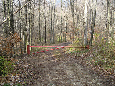
Trailhead west of Burr-Barton Seminary
The real question is, did I put a quarter in?

Directions to trailhead: Take Route 7A south from Manchester, then take a right shortly after the small rotary onto Seminary Avenue. Past the big building, take a right onto an eventually dead end dirt road. There are some signs that say no parking - that's the access to the trailhead, which is just past a big water tank.
Back to Mt. Equinox Profile
|
