Home
States
Colorado
Connecticut
Maine
Massachusetts
New Hampshire
New York
Rhode Island
Utah
Vermont
View All
Lists
NE 4,000 Footers
NE 100 Highest
NH 4,000 Footers
NH 100 Highest
NH 52 With A View
NH Belknap Range
NH Ossipee 10
Links
Trail Conditions
Trip Log
Sunrises
Sunsets
About
|
Mt. Toby
Sunderland, MA
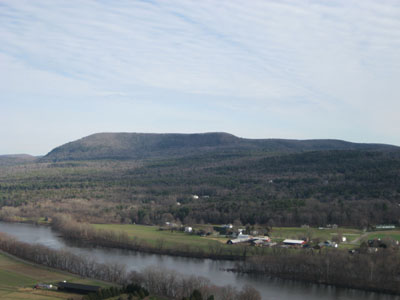
Mt. Toby as seen from South Sugarloaf Mountain
 Summary Summary
Mt. Toby is one of many nice, moderate hikes near the Amherst area in Massachusetts' Pioneer Valley. While the ground level views from the summit aren't that great, a quick climb up the firetower reveals a panorama.
Used mainly by UMass's Forestry Department, there are many trails throughout the reservation for hiking, biking, and horseback riding.
The summit was once home to a hotel. The mountain was briefly considered for alpine ski development in the 1930s.
Summit Elevation
1,269 feet
Summit Facilities
Fire tower
Trip Reports:
Click on the date for photos, timestamps, and maps.
More Information
Mt. Toby - New England's Cancelled Ski Areas
Mount Toby - Wikipedia
|
