Home
States
Colorado
Connecticut
Maine
Massachusetts
New Hampshire
New York
Rhode Island
Utah
Vermont
View All
Lists
NE 4,000 Footers
NE 100 Highest
NH 4,000 Footers
NH 100 Highest
NH 52 With A View
NH Belknap Range
NH Ossipee 10
Links
Trail Conditions
Trip Log
Sunrises
Sunsets
About
|
Galehead Mountain, South Twin Mountain, North Twin Mountain
Bethlehem, NH, Franconia, NH
Trailheads, measurements, times, distances, and maps are all approximate and relative to the hike(s) as shown below.

The Gale River Trail later in the day
Route: Gale River Trail, Garfield Ridge Trail, Frost Trail, (Galehead Mountain), Frost Trail, (Galehead Hut), Frost Trail, Twinway, (South Twin Mountain), North Twin Spur, (North Twin Mountain), North Twin Spur, (South Twin Mountain), Twinway, Frost Trail, (Galehead Hut), Frost Trail, Garfield Ridge Trail, Gale River Trail
I had been planning to hike the Twins and Galehead Mountain via the Gale River Trail for quite awhile - however, time and weather just never allowed. My latest plan was to hike them on Saturday, however a last minute Friday night forecast showed rain. The weather ended up being great most of that day, but oh well.
Plan B. I arrived at the Gale River Trail trailhead just before 7 in pretty crappy weather - dark, drizzly, kind of cold. The weather forecasts said it'd be sunny by late morning, so I decided to take their word for it.
Though I could hear the river roaring through the woods, the crossings weren't bad at all. The first few miles of the Gale River Trail is pretty easy going - easy, gradual pitch, decent footing. Things do not get anywhere near steep until after the second Gale River crossing (where you end up back on the same side of the river that you started on, opps I ended with a preposition. Almost.). At this point, there are a few moderate pitches, until the trail turns up into the mountainside and gets somewhat steep for a few hundred vertical feet.
Up until this point, I hadn't seen a single person. From here forward, crowds were rather heavy.
I found the Garfield Ridge Trail to be just about the most challenging part of this hike - all .6 miles of it. It dips up and down with rather crappy footing. Not only that, but its not wide enough to allow passing - in other words, I was stopping every few minutes to let the overnighters by.
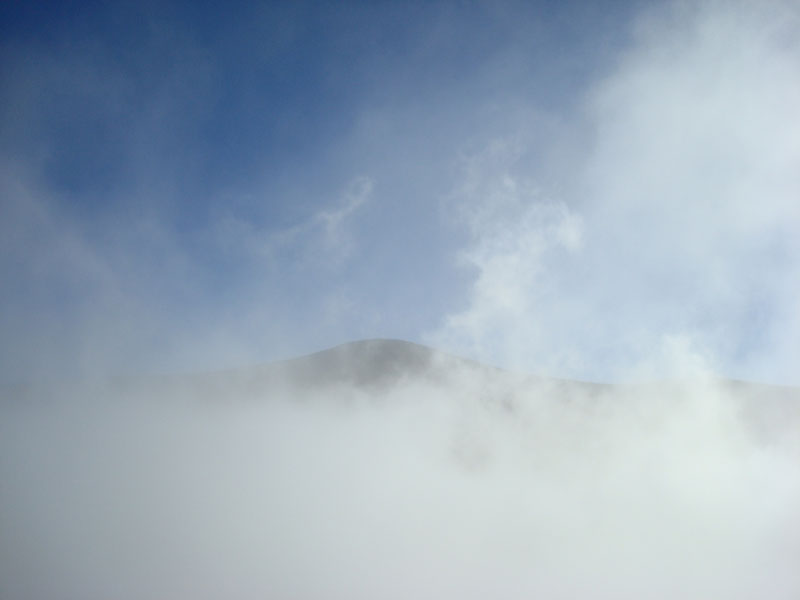
Soon at the hut, I kept chugging to Galehead Mountain. Once starting this last piece of initial ascent, I could see very brief moments of blue sky and sunshine.
After taking a quick break at the infamously dull summit, I went a few minutes back down the trail to the outlook. Though much is said about Galehead being a viewless peak, the outlook is relatively close to the top and does appear to have nice views - when it's clear. Nonetheless, I was able to get brief glimpses of the Twins as the clouds were flying through at warp speed.
Not wanting to summit South Twin Mountain in a cloud, I decided to stop off at the Galehead Hut and burn a little bit of time. Quickly growing impatient, I had a snack and was on my way after ten minutes.
There continued to be somewhat heavy traffic going in the opposite direction as I took the Twinway up to South Twin. I've heard a lot about this section of trail being very steep, but it really didn't seem that bad. It gains over 1,000 feet in less than a mile, but to me it felt a lot less vertical.
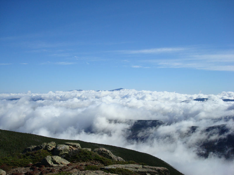
The summit was brilliant - the clouds to the west were at just over 4,000 feet, so the Franconia Ridge was sticking out in a neat way. To the northeast, Mt. Washington was just barely sticking through a blanket of clouds.
After enjoying the views for a bit, I continued to North Twin Mountain. With the exception of two large rocks, it's an easy to moderate pitch the whole way. The scenery from the view ledge is great - though not nearly as awesome as South Twin. Nonetheless, the relative flats to the north had an excellent red tint to them, and the valley to the southwest, surrounded by the Bonds and the Franconia Ridge, had an orange tint with low clouds passing through.
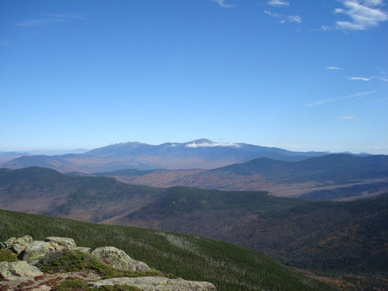
After having lunch on North Twin, I went back to a crowded South Twin Mountain. By now, most of the clouds were long gone and the views were great - Mt. Washington, the Franconia Ridge, the Bonds, Passaconaway, etc. were all easily seen.
The next stop was back at the Galehead Hut, mostly to break up the downhill trip a bit. Very crowded outside on the deck, but nice and quiet on the inside.
The rest of the descent was rather uneventful - the scenery was great due to the peak fall colours down low.
The ride back was to the tune of the Red Sox starting (and later, on television when I made it back home, winning) game 3 of the ALDS. Not bad. Not bad at all.
| Hike Ratings |
|
Getting To Trailhead: |
Easy |
| Destination: |
Galehead Mountain |
|
Length: |
Moderate |
|
Steepness: |
Difficult |
|
Navigation: |
Easy |
|
Views: |
Moderate |
|
Crowds: |
Heavy |
| Destination: |
South Twin Mountain |
|
Length: |
Difficult |
|
Steepness: |
Difficult |
|
Navigation: |
Easy |
|
Views: |
Excellent |
|
Crowds: |
Heavy |
| Destination: |
North Twin Mountain |
|
Length: |
Difficult |
|
Steepness: |
Moderate |
|
Navigation: |
Easy |
|
Views: |
Excellent |
|
Crowds: |
Moderate |
|
| Hike Stats |
|
Date Hiked: |
Sunday, October 7, 2007 |
| Hike Commenced: |
6:58 AM |
| Parking Elevation: |
1,610' |
| Destination: |
Galehead Mountain |
| Ascent Commenced: |
6:58 AM |
| Summit Reached: |
9:18 AM |
| Time Elapsed: |
02:20 |
| Trailhead Elevation: |
1,610' |
| Summit Elevation: |
4,024' |
| Distance: |
5.1 miles |
| Vertical Gain: |
2,609' |
| Destination: |
Galehead Hut |
| Descent Commenced: |
9:22 AM |
| Hut Reached: |
9:38 AM |
| Time Elapsed: |
00:16 |
| Trailhead Elevation: |
4,024' |
| Hut Elevation: |
3,800' |
| Distance: |
.5 miles |
| Vertical Gain: |
50' |
| Destination: |
South Twin Mountain |
| Ascent Commenced: |
9:49 AM |
| Summit Reached: |
10:25 AM |
| Time Elapsed: |
00:36 |
| Trailhead Elevation: |
3,800' |
| Summit Elevation: |
4,902' |
| Distance: |
.8 miles |
| Vertical Gain: |
1,137' |
| Destination: |
North Twin Mountain |
| Ascent Commenced: |
10:35 AM |
| Summit Reached: |
11:07 AM |
| Time Elapsed: |
00:32 |
| Trailhead Elevation: |
4,902' |
| Summit Elevation: |
4,761' |
| Distance: |
1.3 miles |
| Vertical Gain: |
321' |
|
|
| Hike Ended: |
2:55 PM |
| Hike Time Elapsed: |
07:57 |
| Hike Distance: |
14.4 miles |
| Hike Vertical Gain: |
4,754' |
|

The Gale River Trail trailhead

The Gale River Trail on a wet morning

The Twins barely showing through the clouds from near the top of Galehead Mountain

Looking up Twinway to South Twin Mountain

Looking at Mt. Washington from the South Twin Mountain summit

Looking at Mt. Washington from South Twin Mountain later in the day

Looking out at the North Twin Spur Trail on the way to North Twin Mountain

Looking into the Pemi from North Twin Mountain


Directions to trailhead: Take Route 3 South from US 302. Take a left for the Gale River camping/hiking area. Shortly after, bear left at the fork in the road. Continue down the road, then take a right at the hiker sign. The WMNF fee parking area is on the left. There is a Gale River Trail trailhead on the side of the parking area.
Back to Galehead Mountain Profile
Back to South Twin Mountain Profile
Back to North Twin Mountain Profile
|