Home
States
Colorado
Connecticut
Maine
Massachusetts
New Hampshire
New York
Rhode Island
Utah
Vermont
View All
Lists
NE 4,000 Footers
NE 100 Highest
NH 4,000 Footers
NH 100 Highest
NH 52 With A View
NH Belknap Range
NH Ossipee 10
Links
Trail Conditions
Trip Log
Sunrises
Sunsets
About
|
Gunstock Mountain, Belknap Mountain, Piper Mountain
Gilmanton, NH, Gilford, NH
Trailheads, measurements, times, distances, and maps are all approximate and relative to the hike(s) as shown below.

Looking up the Gunstock Mountain Trail
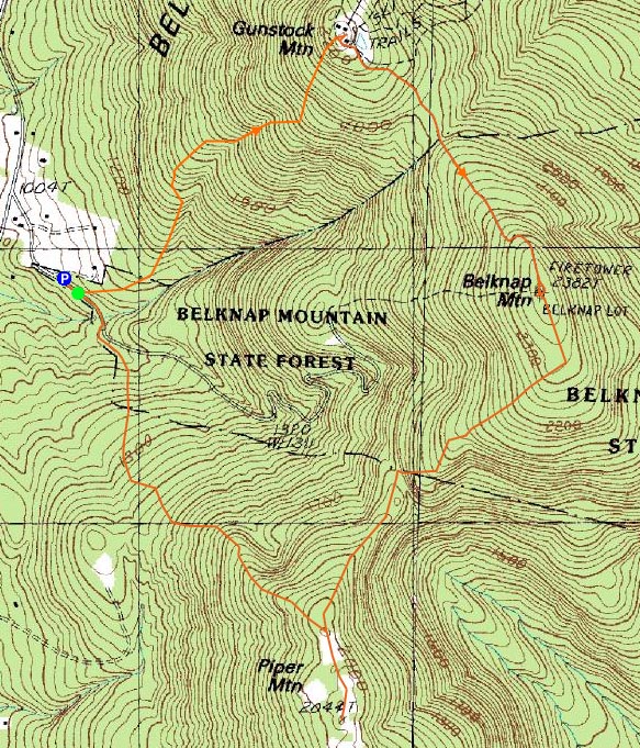
Route: Carriage Road, Gunstock Mountain Trail, (Gunstock Mountain), Saddle Trail, Blue Trail, (Belknap Mountain), White Trail, Old Piper Trail, green blazed trail, (Piper Mountain), green blazed trail, Piper Trail, Carriage Road
Our original plan had been to do a snow-free hike down in the Blue Hills of Massachusetts. The weather forecasts all agreed that this would not be a good idea, however, so we decided to move our venue a bit to the north.
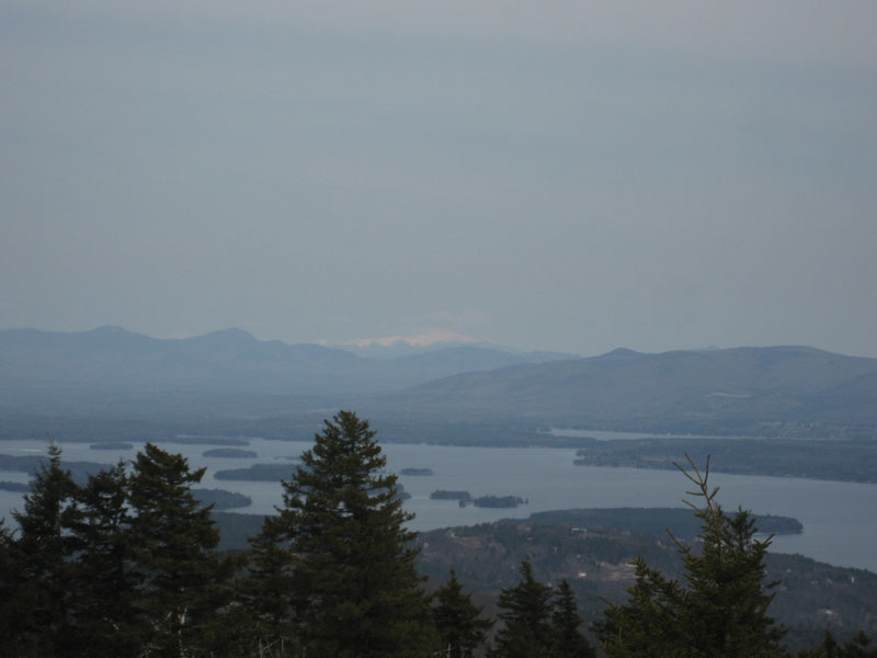
Starting on the Gunstock Mountain Trail, we had snow-free hiking for the bulk of the ascent. As we neared 2,000 feet, however, we encountered ice and increasing amounts of snow. Arriving at the summit, we had cloudy skies with decent views - snow capped peaks including the Presidentials and Franconias jumped out in the distance.
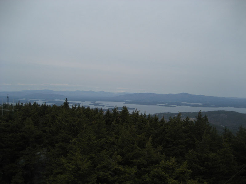
Our next stop we Belknap Mountain. The trails in between were a bit tricky, with constant ice and snow monorail. The views from the summit fire tower were good, though limited to the south and west. While windy on the tower, things were calm enough at the base of it for a leisurely lunch.
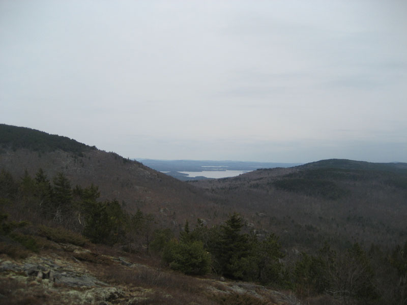
Our final stop of the day was Piper Mountain. My first time on the White Trail (other than the top portion), I was surprised by the multiple ledge viewpoints along the way. We left it awhile later, talking the Old Piper Trail to the top of the ridge, then working our way over the mostly bare ledges to the highpoint. Near the highpoint, we had nice views toward Lake Winnipesaukee.
The first portion of the descent on the Piper Trail was a bit tricky due to ice, however things went a bit more smoothly as we dropped in elevation. Though the forecast called for decreasing clouds, we still had full cloud cover overhead by the end of the hike. It did not rain, however, making the relocated plan a success!
| Hike Ratings |
|
Getting To Trailhead: |
Easy |
| Destination: |
Gunstock Mountain |
|
Length: |
Moderate |
|
Steepness: |
Moderate |
|
Navigation: |
Easy |
|
Views: |
Excellent |
|
Crowds: |
Minimal |
| Destination: |
Belknap Mountain |
|
Length: |
Moderate |
|
Steepness: |
Moderate |
|
Navigation: |
Moderate |
|
Views: |
Excellent |
|
Crowds: |
Minimal |
| Destination: |
Piper Mountain |
|
Length: |
Moderate |
|
Steepness: |
Moderate |
|
Navigation: |
Easy |
|
Views: |
Excellent |
|
Crowds: |
Minimal |
|
| Hike Stats |
|
Date Hiked: |
Saturday, April 11, 2009 |
| Hike Commenced: |
10:45 AM |
| Parking Elevation: |
1,030' |
| Destination: |
Gunstock Mountain |
| Ascent Commenced: |
10:47 AM |
| Summit Reached: |
11:38 AM |
| Time Elapsed: |
00:51 |
| Trailhead Elevation: |
1,020' |
| Summit Elevation: |
2,245' |
| Vertical Gain: |
1,225' |
| Destination: |
Belknap Mountain |
| Ascent Commenced: |
11:59 AM |
| Summit Reached: |
12:47 PM |
| Time Elapsed: |
00:48 |
| Trailhead Elevation: |
2,245' |
| Summit Elevation: |
2,382' |
| Vertical Gain: |
407' |
| Destination: |
Piper Mountain |
| Ascent Commenced: |
1:29 PM |
| Summit Reached: |
2:25 PM |
| Time Elapsed: |
00:56 |
| Trailhead Elevation: |
2,382' |
| Summit Elevation: |
2,044' |
| Vertical Gain: |
344' |
|
|
| Hike Ended: |
3:14 PM |
| Hike Time Elapsed: |
04:29 |
| Hike Vertical Gain: |
2,011' |
|

The Gunstock Mountain Trail trailhead on the Carriage Road

Looking at the Sandwich, Presidential, and Ossipee Ranges from Gunstock Mountain

The Saddle Trail on the way to Belknap Mountain

Looking at the Sandwich, Presidential, and Ossipee Ranges from the Belknap Mountain fire tower

The White Trail between Belknap Mountain and Piper Mountain

Looking at Lake Winnipesaukee from Piper Mountain


Directions to trailhead: From Route 11A East (from Route 3), take a right on Hoyt Road. Continue down this road as it becomes Belknap Mountain Road. Look for Carriage Road on your left - offseason parking is at the gate.
Back to Gunstock Mountain Profile
Back to Belknap Mountain Profile
Back to Piper Mountain Profile
|