Home
States
Colorado
Connecticut
Maine
Massachusetts
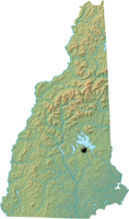
New Hampshire
New York
Rhode Island
Utah
Vermont
View All
Lists
NE 4,000 Footers
NE 100 Highest
NH 4,000 Footers
NH 100 Highest
NH 52 With A View
NH Belknap Range
NH Ossipee 10
Links
Trail Conditions
Trip Log
Sunrises
Sunsets
About
|
Belknap Mountain
Gilford, NH
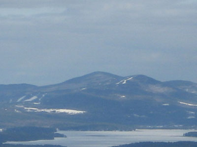
Belknap Mountain as seen from Red Hill
 Summary Summary
Belknap Mountain is the highest point in Belknap County. While the summit is viewless, the fire tower/observation deck (just below the cab) has views in all directions.
On June 18, 1972, a Piper airplane departing from the Laconia airport en route to Great Barrington, MA, went missing in poor weather conditions. Nearly a year later, a few local residents decided to hike up to a shining object they had seen from below. On June 3, 1972, the bodies of the two on board the plane were recovered when the crash site was discovered.
The crash site remains relatively in tact today.
Summit Elevation
2,382 feet
Summit Facilities
Firetower.
Relics
1972 Piper plane wreck on upper northeast slope.
Trip Reports:
Click on the date for photos, timestamps, and maps.
| Date of Hike |
Trail(s) |
Length |
Steepness |
Vertical |
|
| May 10, 2021 |
Gunstock Mountain Trail, more |
Moderate |
Moderate |
1,682' |
| July 10, 2019 |
Gunstock Mountain Trail, more |
Moderate |
Moderate |
1,682' |
| October 19, 2018 |
Green Trail, more |
Moderate |
Difficult |
1,422' |
| August 2, 2018 |
Gunstock Mountain Trail, more |
Moderate |
Moderate |
1,682' |
| May 31, 2018 |
Gunstock Mountain Trail, more |
Moderate |
Moderate |
1,682' |
| May 16, 2018 |
Piper Mountain Trail, more |
Moderate |
Moderate |
2,011' |
| August 8, 2017 |
Gunstock Mountain Trail, more |
Moderate |
Moderate |
2,011' |
| July 5, 2017 |
Wardens Trail, more |
Moderate |
Difficult |
722' |
| June 20, 2017 |
Gunstock Mountain Trail, more |
Moderate |
Moderate |
1,682' |
| December 4, 2016 |
Round Pond Trail, more |
Moderate |
Difficult |
2,524' |
| October 29, 2016 |
Gunstock Mountain Trail, more |
Moderate |
Moderate |
1,682' |
| October 7, 2016 |
Blue Trail, more |
Moderate |
Difficult |
1,412' |
| September 7, 2016 |
Carriage Road, more |
Moderate |
Moderate |
1,682' |
| August 15, 2016 |
Gunstock Mountain Trail, more |
Moderate |
Moderate |
2,011' |
| June 22, 2016 |
Carriage Road, more |
Moderate |
Moderate |
1,682' |
| June 7, 2016 |
Gunstock Mountain Trail, more |
Moderate |
Moderate |
1,682' |
| May 27, 2016 |
Gunstock Mountain Trail, more |
Moderate |
Moderate |
1,682' |
| May 19, 2016 |
Piper Mountain Trail, more |
Moderate |
Difficult |
1,686' |
| May 8, 2016 |
Gunstock Mountain Trail, more |
Moderate |
Moderate |
1,682' |
| March 31, 2016 |
Gunstock Mountain Trail, more |
Moderate |
Moderate |
2,011' |
| February 2, 2016 |
Gunstock Mountain Trail, more |
Moderate |
Moderate |
1,682' |
| November 7, 2015 |
Red Trail, more |
Moderate |
Difficult |
722' |
| October 27, 2015 |
Red Trail |
Moderate |
Difficult |
722' |
| October 15, 2015 |
Red Trail |
Moderate |
Difficult |
722' |
| October 12, 2015 |
Gunstock Mountain Trail, more |
Moderate |
Moderate |
2,011' |
| October 1, 2015 |
Red Trail |
Moderate |
Difficult |
722' |
| October 1, 2015 |
Red Trail |
Moderate |
Difficult |
722' |
| September 23, 2015 |
Red Trail |
Moderate |
Difficult |
722' |
| September 14, 2015 |
Red Trail |
Moderate |
Difficult |
722' |
| September 4, 2015 |
Blue Trail |
Moderate |
Moderate |
727' |
| August 28, 2015 |
Blue Trail |
Moderate |
Moderate |
742' |
| August 22, 2015 |
Blue Trail |
Moderate |
Moderate |
722' |
| August 18, 2015 |
Red Trail |
Moderate |
Difficult |
722' |
| August 15, 2015 |
White Trail, more |
Moderate |
Moderate |
822' |
| August 12, 2015 |
Red Trail |
Moderate |
Difficult |
722' |
| August 4, 2015 |
Boulder Trail, more |
Moderate |
Difficult |
1,817' |
| July 28, 2015 |
Red Trail |
Moderate |
Difficult |
722' |
| July 22, 2015 |
Red Trail |
Moderate |
Difficult |
722' |
| July 15, 2015 |
Red Trail |
Moderate |
Difficult |
722' |
| July 10, 2015 |
Blue Trail |
Moderate |
Moderate |
722' |
| July 8, 2015 |
Red Trail |
Moderate |
Difficult |
722' |
| June 30, 2015 |
Green Trail, more |
Moderate |
Difficult |
722' |
| June 27, 2015 |
Red Trail, more |
Moderate |
Difficult |
722' |
| June 16, 2015 |
Red Trail |
Moderate |
Difficult |
722' |
| June 11, 2015 |
Red Trail |
Moderate |
Difficult |
722' |
| June 10, 2015 |
Piper-Round Pond Link, more |
Moderate |
Difficult |
1,292' |
| May 27, 2015 |
Piper Mountain Trail, more |
Moderate |
Difficult |
1,686' |
| May 26, 2015 |
Red Trail |
Moderate |
Difficult |
722' |
| May 22, 2015 |
Green Trail, more |
Moderate |
Difficult |
722' |
| May 20, 2015 |
Red Trail |
Moderate |
Difficult |
722' |
| May 17, 2015 |
Red Trail |
Moderate |
Difficult |
722' |
| May 12, 2015 |
Red Trail |
Moderate |
Difficult |
722' |
| May 8, 2015 |
Green Trail, more |
Moderate |
Difficult |
722' |
| April 30, 2015 |
Gunstock Mountain Trail, more |
Moderate |
Moderate |
1,682' |
| April 1, 2015 |
Green Trail, more |
Moderate |
Difficult |
1,412' |
| March 17, 2015 |
Red Trail, more |
Moderate |
Difficult |
1,412' |
| October 20, 2014 |
Round Pond Trail, more |
Moderate |
Difficult |
1,622' |
| September 19, 2014 |
Gunstock Mountain Trail, more |
Moderate |
Moderate |
1,682' |
| August 9, 2014 |
Red Trail, more |
Moderate |
Difficult |
722' |
| July 29, 2014 |
Red Trail |
Moderate |
Difficult |
722' |
| July 25, 2014 |
Red Trail |
Moderate |
Difficult |
722' |
| July 17, 2014 |
Red Trail |
Moderate |
Difficult |
722' |
| July 12, 2014 |
Green Trail, more |
Moderate |
Difficult |
722' |
| July 9, 2014 |
Red Trail, more |
Moderate |
Difficult |
722' |
| July 6, 2014 |
Red Trail |
Moderate |
Difficult |
722' |
| July 1, 2014 |
Red Trail |
Moderate |
Difficult |
722' |
| June 28, 2014 |
Red Trail, more |
Moderate |
Difficult |
742' |
| June 24, 2014 |
Red Trail, more |
Moderate |
Difficult |
742' |
| June 23, 2014 |
Piper Mountain Trail, more |
Moderate |
Difficult |
1,686' |
| June 14, 2014 |
Red Trail, more |
Moderate |
Moderate |
742' |
| May 24, 2014 |
Red Trail, more |
Moderate |
Difficult |
722' |
| November 1, 2013 |
Piper Mountain Trail, more |
Moderate |
Difficult |
1,686' |
| October 26, 2013 |
Blue Trail |
Moderate |
Moderate |
742' |
| September 4, 2013 |
Piper Mountain Trail, more |
Moderate |
Difficult |
1,966' |
| July 16, 2013 |
Gunstock Mountain Trail, more |
Moderate |
Moderate |
1,682' |
| June 20, 2013 |
Piper Mountain Trail, more |
Moderate |
Difficult |
1,676' |
| May 31, 2012 |
Piper Mountain Trail, more |
Moderate |
Difficult |
1,746' |
| April 21, 2011 |
Gunstock Mountain Trail, more |
Moderate |
Moderate |
1,682' |
| July 1, 2010 |
Red Trail, more |
Moderate |
Difficult |
897' |
| April 11, 2009 |
Gunstock Mountain Trail, more |
Moderate |
Moderate |
2,011' |
| December 20, 2008 |
Gunstock Mountain Trail, more |
Moderate |
Moderate |
1,682' |
| July 29, 2008 |
East Gilford Trail, more |
Moderate |
Difficult |
1,624' |
| November 23, 2007 |
Various |
Moderate |
Difficult |
1,817' |
| April 13, 2007 |
Green Trail, more |
Moderate |
Moderate |
1,412' |
|
More Information
- Belknap Range List
- Belknap Mountain - Wikipedia
- Belknap - NHMountainHiking.com
- NYC72AN158 - NTSB.gov - 1972 Piper Accident Report
|
