Home
States
Colorado
Connecticut
Maine
Massachusetts
New Hampshire
New York
Rhode Island
Utah
Vermont
View All
Lists
NE 4,000 Footers
NE 100 Highest
NH 4,000 Footers
NH 100 Highest
NH 52 With A View
NH Belknap Range
NH Ossipee 10
Links
Trail Conditions
Trip Log
Sunrises
Sunsets
About
|
Mt. Eisenhower, Mt. Pierce, Mt. Jackson
Bean's Grant, NH, Chandler's Purchase, NH, Sargent's Purchase, NH
Trailheads, measurements, times, distances, and maps are all approximate and relative to the hike(s) as shown below.

The Crawford Path
Route: Crawford Path, Eisenhower Loop, (Mt. Eisenhower), Eisenhower Loop, Crawford Path, Webster Cliff Trail, (Mt. Pierce), Webster Cliff Trail, (Mt. Jackson), Webster-Jackson Trail
If I did not have snowshoes, this hike would not have been possible.
Crawford Path up to the Mizpah junction was fairly well packed out. Decent snowshoeing. Above the Mizpah junction, it had not seen much use as of this morning. Soft with drifts. Snowshoes a good idea. Footbed does reach the Webster Cliff junction, but there are various tracks from near there to the summit as well.
From the Webster Cliff junction, one parasitic postholer had attempted to get Eisenhower, but failed miserably after 1/10th of a mile and either turned around or else is still off trail in the trees (did not see return tracks). Beyond there, the trail had seen one or two sets of snowshoes before lots of drifting. Portions are off trail, which I attempted to correct. Sections have 6 or more feet of snowpack. It is negligent to be out here without snowshoes.
Eisenhower Loop had some drifts and some extended ice flows. My Flex Alps snowshoes were ideal (full grip every step), but I would be a little hesitant with just spikes.
From Pierce, the Webster Cliff Trail had seen little use, and the tracks are all over the place. A group of barebooters without snowshoes planned to head to Jackson, but didn't even know where the trail was (and thought it was heading toward Eisenhower). There was so much snow that the tree tops are at your ankles or knees at the summit. I lost the trail a few times before getting to the hut and was off trail about 30% of the time. There are snow shoe tracks all over the places from various people. Mine were way off in places as I navigated my way to the subpeak so that I could regain the trail (portions of the corridor were either clogged with branches due to snowpack or blowdown).
Ran into a group of barebooters at the hut that had who thought they were on the Crawford Path, presumably because the Mizpah Cutoff was more packed than the upper Crawford Path. They turned around when they became aware of the lack of a packed track. It should also be noted that the upper Mizpah Cutoff track is not on the trail and that no one had been to the Mizpah Cutoff-Webster Cliff junction in some time.
Initially southbound from there, the trail was littered with hidden postholes under the powder from a parasitic postholer from the past, making for vexing trail breaking. Fortunately they didn't get far. There was an occasional snowshoe trench noticeable from before the last storm, but it deviated from the trail, as did I in other places. I had it at the marsh crossings and closer to Jackson, but was off in other places (sometimes on purpose because it was clogged with branches). Near the Jackson cone, I encountered fresh parasitic postholer tracks...it was apparent they also didn't get far, and didn't have a good time reclimbing in their postholes in Microspikes. Maybe they will bring snowshoes next time?
The vast majority of Jackson hikers were Microspiking and looking quite foolish, as they were spinning their wheels in the powder (putting in a lot of effort to climb) and struggling with the blue ice on the summit cone (especially when descending). Flex Alp snowshoes gripped the ice just fine.
Nice weather, albeit with a chilly breeze early. I cannot emphasize enough how deep the snow is on the ridge, and with the incoming storm, any remaining blazes on the Webster Cliff Trail will likely be buried.
| Hike Ratings |
|
Getting To Trailhead: |
Easy |
| Destination: |
Mt. Eisenhower |
|
Length: |
Moderate |
|
Steepness: |
Moderate |
|
Navigation: |
Difficult |
|
Views: |
Excellent |
|
Crowds: |
Minimal |
| Destination: |
Mt. Pierce |
|
Length: |
Moderate |
|
Steepness: |
Moderate |
|
Navigation: |
Easy |
|
Views: |
Excellent |
|
Crowds: |
Moderate |
| Destination: |
Mt. Jackson |
|
Length: |
Difficult |
|
Steepness: |
Difficult |
|
Navigation: |
Difficult |
|
Views: |
Excellent |
|
Crowds: |
Heavy |
|
| Hike Stats |
|
Date Hiked: |
Saturday, February 23, 2019 |
| Parking Elevation: |
1,900' |
| Destination: |
Mt. Eisenhower |
| Time Elapsed: |
02:48 |
| Trailhead Elevation: |
1,910' |
| Summit Elevation: |
4,780' |
| Vertical Gain: |
3,300 |
| Destination: |
Mt. Pierce |
| Time Elapsed: |
00:54 |
| Trailhead Elevation: |
4,780' |
| Summit Elevation: |
4,310' |
| Vertical Gain: |
420' |
| Destination: |
Mt. Jackson |
| Time Elapsed: |
01:59 |
| Trailhead Elevation: |
4,310' |
| Summit Elevation: |
4,052' |
| Vertical Gain: |
558' |
|
|
| Hike Time Elapsed: |
06:49 |
| Hike Vertical Gain: |
4,463' |
|

The Crawford Path trailhead

Looking at Mt. Eisenhower from Mt. Pierce

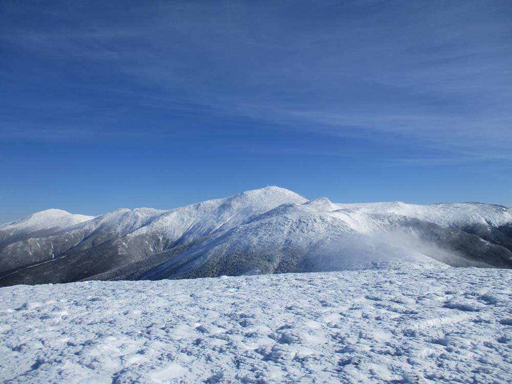
Looking at Mt. Washington from Mt. Eisenhower

The Crawford Path between Mt. Pierce at Mt. Eisenhower

Deep drifts on the Webster Cliff Trail

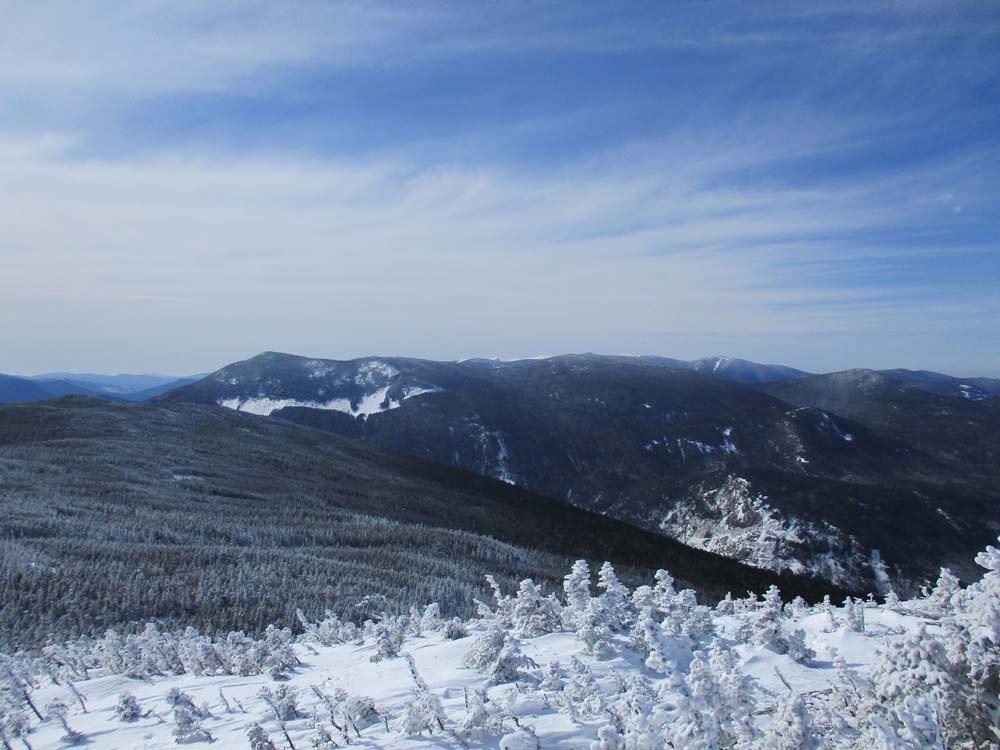
Looking at the Willey Range from Mt. Jackson
Directions to trailhead: Take Route 302 West from Bartlett into Carroll. The Highland Center parking lot is located on the left shortly after the Webster-Jackson trailhead (right). The Crawford Path trailhead is located just beyond the Highland Center parking lot, on the right.
Back to Mt. Eisenhower Profile
Back to Mt. Pierce Profile
Back to Mt. Jackson Profile
|