Home
States
Colorado
Connecticut
Maine
Massachusetts
New Hampshire
New York
Rhode Island
Utah
Vermont
View All
Lists
NE 4,000 Footers
NE 100 Highest
NH 4,000 Footers
NH 100 Highest
NH 52 With A View
NH Belknap Range
NH Ossipee 10
Links
Trail Conditions
Trip Log
Sunrises
Sunsets
About
|
Mt. Eisenhower
Chandler's Purchase, NH
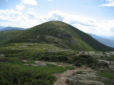
Mt. Eisenhower as seen from the Crawford Path
 Summary Summary
Mt. Eisenhower, formerly known as Mt. Pleasant, is the named after the former general and United States President. Its grassy summit features views in all directions.
Due to the seasonal closure of Mt. Clinton Road (Edmands Path trailhead), Mt. Eisenhower becomes more difficult to access in winter.
Summit Elevation
4,780 feet
Summit Facilities
None.
Trails
The Mt. Eisenhower Loop crosses the summit of Mt. Eisenhower and can be accessed via the Crawford Path, Edmands Path, or Mt. Eisenhower Trail.
Trip Reports:
Click on the date for photos, timestamps, and maps.
| Date of Hike |
Trail(s) |
Length |
Steepness |
Vertical |
|
| April 20, 2021 |
Crawford Path, more |
Difficult |
Difficult |
4,463' |
| November 11, 2020 |
Edmands Path, more |
Moderate |
Moderate |
2,925' |
| May 17, 2020 |
Crawford Path, more |
Difficult |
Difficult |
4,463' |
| February 23, 2019 |
Crawford Path, more |
Difficult |
Difficult |
4,463' |
| July 9, 2018 |
Crawford Path, more |
Moderate |
Difficult |
3,760' |
| October 3, 2017 |
Edmands Path, more |
Moderate |
Moderate |
2,925' |
| September 20, 2017 |
Edmands Path, more |
Moderate |
Moderate |
2,925' |
| March 19, 2017 |
Crawford Path, more |
Difficult |
Difficult |
4,463' |
| January 2, 2017 |
Crawford Path, more |
Difficult |
Difficult |
4,463' |
| August 26, 2014 |
Edmands Path, more |
Moderate |
Moderate |
2,925' |
| December 15, 2012 |
Crawford Path, more |
Moderate |
Difficult |
3,770' |
| August 11, 2012 |
Edmands Path, more |
Moderate |
Moderate |
2,925' |
| January 8, 2012 |
Edmands Path, more |
Moderate |
Moderate |
2,925' |
| September 27, 2011 |
Edmands Path, more |
Moderate |
Moderate |
2,925' |
| July 24, 2011 |
Ammonoosuc Ravine Trail, more |
Moderate |
Difficult |
3,932' |
| July 17, 2011 |
Mt. Eisenhower Trail, more |
Difficult |
Difficult |
4,595' |
| June 15, 2011 |
Edmands Path, more |
Moderate |
Moderate |
2,925' |
| April 22, 2011 |
Crawford Path, more |
Moderate |
Difficult |
3,770' |
| December 26, 2010 |
Ammonoosuc Ravine Trail, more |
Difficult |
Very Difficult |
5,098' |
| February 21, 2010 |
Crawford Path, more |
Difficult |
Difficult |
4,463' |
| December 31, 2009 |
Ammonoosuc Ravine Trail, more |
Difficult |
Very Difficult |
5,048' |
| November 22, 2009 |
Jewell Trail, more |
Difficult |
Very Difficult |
5,098' |
| August 3, 2009 |
Edmands Path, more |
Moderate |
Moderate |
2,925' |
| June 2, 2009 |
Edmands Path, more |
Moderate |
Moderate |
2,925' |
| May 13, 2009 |
Crawford Path, more |
Moderate |
Difficult |
3,770' |
| April 19, 2009 |
Ammonoosuc Ravine Trail, more |
Difficult |
Very Difficult |
5,048' |
| March 28, 2009 |
Webster-Jackson Trail, more |
Difficult |
Difficult |
5,343 |
| January 3, 2009 |
Crawford Path, more |
Moderate |
Difficult |
3,770' |
| October 8, 2008 |
Edmands Path, more |
Moderate |
Moderate |
2,925' |
| September 18, 2008 |
Crawford Path, more |
Moderate |
Difficult |
3,770' |
| July 3, 2007 |
Edmands Path, more |
Difficult |
Difficult |
4,314' |
|
More Information
- New Hampshire 4,000 Foot Peaks
- New England 4,000 Foot Peaks
- New England 100 Highest Peaks
- Dwight Eisenhower - The White House - The mountain's namesake
- Mt. Eisenhower Trail Conditions - NewEnglandTrailConditions.com
|
