Home
States
Colorado
Connecticut
Maine
Massachusetts
New Hampshire
New York
Rhode Island
Utah
Vermont
View All
Lists
NE 4,000 Footers
NE 100 Highest
NH 4,000 Footers
NH 100 Highest
NH 52 With A View
NH Belknap Range
NH Ossipee 10
Links
Trail Conditions
Trip Log
Sunrises
Sunsets
About
|
Mt. Pierce, Mt. Eisenhower
Bean's Grant, NH, Chandler's Purchase, NH
Trailheads, measurements, times, distances, and maps are all approximate and relative to the hike(s) as shown below.

Looking down the Crawford Path
Route: Crawford Connector, Crawford Path, Webster Cliff Trail, (Mt. Pierce), Webster Cliff Trail, Crawford Path, Mt. Eisenhower Loop, (Mt. Eisenhower), Mt. Eisenhower Loop, Crawford Path, Crawford Connector
With a decent weather forecast, I decided to take a few hours off from work and head up to the Southern Presidentials for the afternoon.
The bum knee was a bit sore for the first portion of the hike, however it did seem to improve prior to reaching the Mizpah junction. At that junction, consistent snow monorail started, lasting all the way to the treeline.
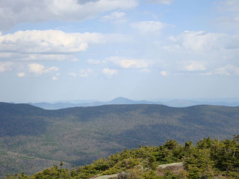
The views from Mt. Pierce were quite good - the Presidentials to the north were in the clear and peaks to the east were easily seen. After some stretching, I headed over to Mt. Eisenhower.
This stretch of the Crawford Path featured occasional deep patches of snow in the trees - fortunately these were few and far between. The upper portions of the Eisenhower Loop were filled in with some fairly fresh snow - nothing like new snow in mid-May!
The views from Mt. Eisenhower were quite good as well - though points to the west were hazy, all other directions were easily seen. Not a bad day for the Southern Presidentials!
| Hike Ratings |
|
Getting To Trailhead: |
Easy |
| Destination: |
Mt. Pierce |
|
Length: |
Moderate |
|
Steepness: |
Moderate |
|
Navigation: |
Easy |
|
Views: |
Excellent |
|
Crowds: |
Minimal |
| Destination: |
Mt. Eisenhower |
|
Length: |
Moderate |
|
Steepness: |
Difficult |
|
Navigation: |
Easy |
|
Views: |
Excellent |
|
Crowds: |
Minimal |
|
| Hike Stats |
|
Date Hiked: |
Wednesday, May 13, 2009 |
| Hike Commenced: |
2:07 PM |
| Parking Elevation: |
1,920' |
| Destination: |
Mt. Pierce |
| Ascent Commenced: |
2:07 PM |
| Summit Reached: |
3:48 PM |
| Time Elapsed: |
01:41 |
| Trailhead Elevation: |
1,920' |
| Summit Elevation: |
4,310' |
| Distance: |
3.2 miles |
| Vertical Gain: |
2,430' |
| Destination: |
Mt. Eisenhower |
| Ascent Commenced: |
3:53 PM |
| Summit Reached: |
4:42 PM |
| Time Elapsed: |
00:49 |
| Trailhead Elevation: |
4,310' |
| Summit Elevation: |
4,780' |
| Distance: |
1.7 miles |
| Vertical Gain: |
920' |
|
|
| Hike Ended: |
7:11 PM |
| Hike Time Elapsed: |
05:04 |
| Hike Vertical Gain: |
3,770' |
|

Crawford Connector trailhead

A painted trillium along the Crawford Connector

Looking at Kearsarge North Mountain from near the summit of Mt. Pierce

Looking up the Mt. Eisenhower Loop trail

The view from the Mt. Eisenhower summit


Directions to trailhead: Take Route 302 West from Bartlett into Carroll. Just after Saco Lake, take a right onto Mt. Clinton Road. Shortly thereafter, take a left into the WMNF fee parking area driveway and Crawford Connector trailhead.
Back to Mt. Pierce Profile
Back to Mt. Eisenhower Profile
|