Home
States
Colorado
Connecticut
Maine
Massachusetts
New Hampshire
New York
Rhode Island
Utah
Vermont
View All
Lists
NE 4,000 Footers
NE 100 Highest
NH 4,000 Footers
NH 100 Highest
NH 52 With A View
NH Belknap Range
NH Ossipee 10
Links
Trail Conditions
Trip Log
Sunrises
Sunsets
About
|
North Twin Mountain, South Twin Mountain, Galehead Mountain
Bethlehem, NH, Franconia, NH
Trailheads, measurements, times, distances, and maps are all approximate and relative to the hike(s) as shown below.
The North Twin Trail
Route: Herd path, Haystack Road, North Twin Trail, herd path, North Twin Trail, view spur path, (North Twin Mountain), view spur path, North Twin Spur, (South Twin Mountain), Twinway, Frost Trail, (Galehead Mountain), Frost Trail, Garfield Ridge Trail, Gale River Trail, Gale River Road, connector trail, Beaver Brook XC Ski Trail
While the weather had looked poor for quite some time leading up to the end of the week, things suddenly improved. Thus, it seemed like a good day to do a loop of the Twins and Galehead.
After spotting a vehicle at the Beaver Brook XC parking area, we headed over to Little River Road. Seeing that the 7 Dwarfs Motel parking lot hadn't been plowed, we continued to the end of the road and parked, as there were no signs stating we couldn't. The snowmobile bridge across the Little River - closed as recently as this spring - had been rebuilt.
After taking the skier trail to Haystack Road, we were soon on the North Twin Trail. Bypassing the first two crossings, we were able to get across the third river crossing without too much difficulty, as things were starting to bridge.
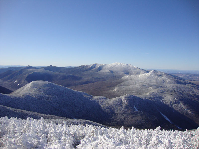
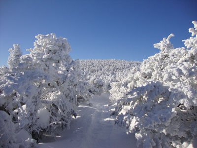
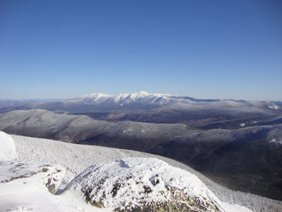
Beyond there, the trail continued to be broken out. Other than dealing with some blowdowns, it was fairly smooth sailing. Nearing the height of land, we could hear the wind a bit. Since we knew the ambient temperature was below zero, we added layers and moved forward. Reaching the first viewpoint, we had tremendous views of the Presidentials.
The trail from the viewpoint to the summit spur junction had been a pain in the neck the previous winter - however, thanks to lots of trail maintenance, it was very easy to follow to North Twin. The views from near the highpoint were spectacular as well - the ski trails on Mt. Mansfield in Vermont were easily seen.
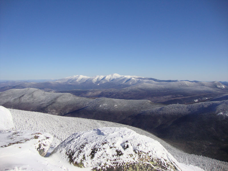
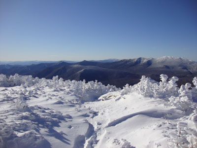
The trail wasn't quite as easy to follow between North and South Twin, as there was snow drifting, as well as an inconvenient blowdown. Nonetheless, we made our way up to the windy summit and enjoyed the views for a few chilly minutes.
The Twinway was pretty smooth sailing - much easier than dealing with the rocks in the summer. Passing the hut, we climbed up Galehead, checked out the near-summit view, then return to the hut for a nice lunch break.
From there, we headed out on the Gale River Trail. The top crossing was done with ease and the bottom crossing just about completely bridged. Below there, we took our time to help remove a large quantity of blowdowns from the wind storm a few weeks prior. Reaching Gale River Road, we headed north, then hopped off at camp site number 3, cut over onto the blue marked cross country ski trail, and worked our way to the Beaver Brook XC parking area.
| Hike Ratings |
|
Getting To Trailhead: |
Moderate |
| Destination: |
North Twin Mountain |
|
Length: |
Moderate |
|
Steepness: |
Difficult |
|
Navigation: |
Moderate |
|
Views: |
Excellent |
|
Crowds: |
Minimal |
| Destination: |
South Twin Mountain |
|
Length: |
Difficult |
|
Steepness: |
Difficult |
|
Navigation: |
Difficult |
|
Views: |
Excellent |
|
Crowds: |
Minimal |
| Destination: |
Galehead Mountain |
|
Length: |
Very Difficult |
|
Steepness: |
Difficult |
|
Navigation: |
Easy |
|
Views: |
Excellent |
|
Crowds: |
Minimal |
|
| Hike Stats |
|
Date Hiked: |
Friday, December 18, 2009 |
| Hike Commenced: |
7:15 AM |
| Parking Elevation: |
1,620' |
| Destination: |
North Twin Mountain |
| Ascent Commenced: |
7:36 AM |
| Summit Reached: |
10:16 AM |
| Time Elapsed: |
02:40 |
| Trailhead Elevation: |
1,800' |
| Summit Elevation: |
4,761' |
| Distance: |
4.3 miles |
| Vertical Gain: |
3,111' |
| Destination: |
South Twin Mountain |
| Ascent Commenced: |
10:18 AM |
| Summit Reached: |
11:01 AM |
| Time Elapsed: |
00:43 |
| Trailhead Elevation: |
4,761' |
| Summit Elevation: |
4,902' |
| Distance: |
1.3 miles |
| Vertical Gain: |
461' |
| Destination: |
Galehead Mountain |
| Ascent Commenced: |
11:02 AM |
| Summit Reached: |
11:47 AM |
| Time Elapsed: |
00:45 |
| Trailhead Elevation: |
4,902' |
| Summit Elevation: |
4,024' |
| Distance: |
1.3 miles |
| Vertical Gain: |
309' |
|
|
| Hike Ended: |
2:45 PM |
| Hike Time Elapsed: |
7:30 |
| Hike Vertical Gain: |
4,356' |
|
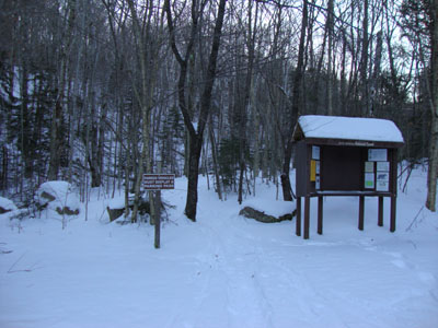
The North Twin Trail trailhead at the end of Haystack Road
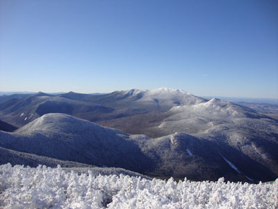
Looking into the Pemi from near the North Twin summit
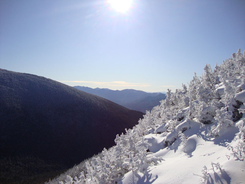
The North Twin Spur on the way to South Twin
Looking at the Presidentials from near the South Twin summit
The Twinway between South Twin and Galehead

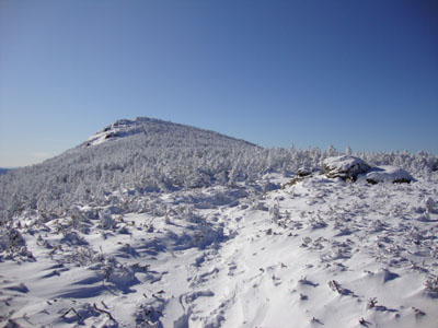
Looking south from the Galehead Mountain vista

Directions to trailhead: In late fall 2009, take Route 3 south past Twin Mountain (from Route 302), then take a left into the Beaver Brook WMNF fee parking area, just before the five corners, spotting a car here. Then, go north on Route 3 to Twin Mountain, taking a right onto Little River Road. As of late fall 2009, the end of the road had room for limited parking (no parking signs removed - 7 Dwarfs Motel offers alternative fee parking in winter), and the snowmobile bridge across the Little River had been rebuilt and reopened. After crossing this bridge, take an immediate sharp left turn onto a skier path, which then leads to Haystack Road, near the North Twin Trail trailhead.
Back to North Twin Mountain Profile
Back to South Twin Mountain Profile
Back to Galehead Mountain Profile
|