Home
States
Colorado
Connecticut
Maine
Massachusetts
New Hampshire
New York
Rhode Island
Utah
Vermont
View All
Lists
NE 4,000 Footers
NE 100 Highest
NH 4,000 Footers
NH 100 Highest
NH 52 With A View
NH Belknap Range
NH Ossipee 10
Links
Trail Conditions
Trip Log
Sunrises
Sunsets
About
|
Kennebago Divide
Seven Ponds, ME
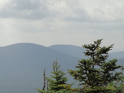
Kennebago Divide as seen behind White Cap Mountain from Boundary Peak
 Summary Summary
Kennebago Divide, located near the Maine-Canada border, features a viewless, trailless highpoint. The peak is considered one of the one hundred highest in New England.
Summit Elevation
3,775 feet
Summit Facilities
None.
Trip Reports:
Click on the date for photos, timestamps, and maps.
More Information
- New England 100 Highest Peaks
- New England 100 Highest Conditions - NewEnglandTrailConditions.com
- Whitecap & Kennebago Divide - Bob & Geri's Adventures
- White Cap and North Kennebago Divide - Papa Bear's Peakbagging Page
- Kennebago Divide - NHMountainHiking.com
- Kennebago Divide - Wikipedia
|
