Home
States
Colorado
Connecticut
Maine
Massachusetts
New Hampshire
New York
Rhode Island
Utah
Vermont
View All
Lists
NE 4,000 Footers
NE 100 Highest
NH 4,000 Footers
NH 100 Highest
NH 52 With A View
NH Belknap Range
NH Ossipee 10
Links
Trail Conditions
Trip Log
Sunrises
Sunsets
About
|
Bald Ledge
Madison, NH
Trailheads, measurements, times, distances, and maps are all approximate and relative to the hike(s) as shown below.
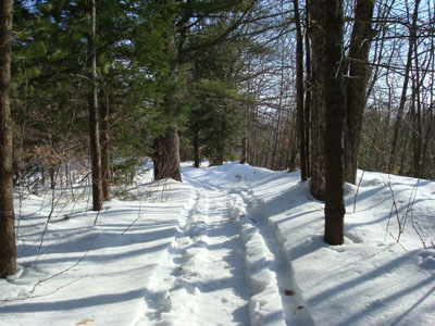
Looking up the snowmobile trail
Route: Unknown snowmobile trail, bushwack, unknown trail, (Bald Ledge), unknown trail, bushwack, unknown snowmobile trail
I've been meaning to explore the hills and mountains in the Madison area for quite some time now. I first saw Bald Ledge years ago on my way to King Pine and thought it looked neat. With a few hours left on a increasingly cloudy day, I figured I'd give it a try.
While Purity Springs Resort has a trail to Bald Ledge, I wasn't quite sure where to find it, where to park, and if I had to pay (since it appeared to cross groomed trails). As a result, I decided to consult my Scrub Oak Scramblers snowmobile map (which I was able to purchase at Watson's store in West Ossipee) and find a way to the ledge. By the looks of the map, it appeared that an L shape trail made its way to Bald Ledge - one branch from near Goe Hill Road and the other from East Madison Road. The Goe Hill approach looked to have some ups and downs by the looks of the topographical map, so I decided to try the latter route.
Arriving at the snowmobile trail, I was able to pull over on the side of the road due to some recent plowing work (to push back snowbanks).
The snowmobile trail had been used prior to the recent thaw, so it was in decent shape for snowshoeing. The trail is rather gradual as it weaves through the woods near some houses and then around the edge of an open field.
At the far end of this field, the snowmobiler had turned around - there was a nasty ditch blocking any progress. Just after this ditch was an intersection with an unplowed road. Taking a right, I continued uphill, passing a gate (and a no snowmobiling sign) and soon a cabin. Just beyond the cabin, the trail enters the woods again, passing another gated area. At one point, I crossed what looked to be a very heavily traveled deer trail.
Soon I was near the top of the ridge and back on a packed snowmobile trail. Notcing that the trail was turning a corner and descending, I continued uphill and bushwacked maybe a tenth of a mile to a ledgy area and to what appeared to be a snowshoeing trail (not used since at least the major rain event almost a week before).
Once on the ledges, I heard quite a sound down the ridge. Pulling out my camera, I was too slow to snap a shot of a group of deer running up some ledges across the way.
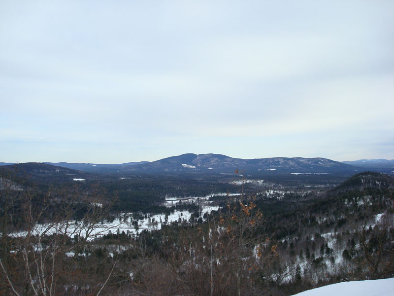
Not loo long after, I was at the high point. There were pretty decent views from this area through some small growth - into Maine, down to Green Mountain, and west to the Ossipee Mountains. There were also stronger unobstructed view points downhill a bit.
With some unfriendly clouds approaching from the west, I didn't spent too much time hanging around. While I was tempted to backtrack and see where the snowshoe trail went, I opted to follow my route back to the bottom.
| Hike Ratings |
|
Getting To Trailhead: |
Moderate |
| Destination: |
Bald Ledge |
|
Length: |
Moderate |
|
Steepness: |
Moderate |
|
Navigation: |
Difficult |
|
Views: |
Excellent |
|
Crowds: |
Minimal |
|
| Hike Stats |
|
Date Hiked: |
Thursday, March 13, 2008 |
| Hike Commenced: |
4:19 PM |
| Parking Elevation: |
790' |
| Destination: |
Bald Ledge |
| Ascent Commenced: |
4:19 PM |
| Summit Reached: |
4:50 PM |
| Time Elapsed: |
00:31 |
| Trailhead Elevation: |
795' |
| Summit Elevation: |
1,183' |
| Vertical Gain: |
413' |
|
|
| Hike Ended: |
5:28 PM |
| Hike Time Elapsed: |
01:09 |
| Hike Vertical Gain: |
468' |
|
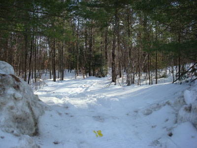
The start of snowmobile trail on East Madison Road

Looking at Green Mountain from near the Bald Ledge summit
Back to Bald Ledge Profile
|