Home
States
Colorado
Connecticut
Maine
Massachusetts
New Hampshire
New York
Rhode Island
Utah
Vermont
View All
Lists
NE 4,000 Footers
NE 100 Highest
NH 4,000 Footers
NH 100 Highest
NH 52 With A View
NH Belknap Range
NH Ossipee 10
Links
Trail Conditions
Trip Log
Sunrises
Sunsets
About
|
Black Cap
Conway, NH
Trailheads, measurements, times, distances, and maps are all approximate and relative to the hike(s) as shown below.
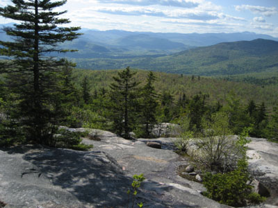
Looking down the Black Cap Trail
Route: Black Cap Trail
In my self designed knee rehab (kneehab?) program, based upon no expert knowledge, I decided to do the quick, easy hike up Black Cap from Hurricane Mountain Road.
I had previously done Great Hill with very little pain a few days earlier, so I felt rested and ready.
There were a few cars at the Hurricane Mountain Road parking area, however I likely met all of the owners descending within the first half mile.
The trailhead was somewhat difficult to find due to a bunch of blowdowns, however after looking around the back of the parking lot, I found a somewhat concealed "trail" sign and a corridor cut through some downed trees.
The trail was gentle and easy to follow until past the Cranmore Trail intersection. Shortly thereafter there was a fork in the trail - fortunately I saw a fading arrow on a rock pointing me to the left. From here, the trail steepens a bit (nothing more than moderate steepness), arriving at quasi-open ledges.
Though the top of Black Cap isn't completely bare, there are plenty of views from all over the exposed ledges. There are also two very short spur trails - one with a viewpoint to the east and another to the west.
I maintained a decent pace during the ascent and had no knee pain. The descent, however, was another story. After maybe 5 minutes, I felt pain starting to return in its normal place and by the end of the hike, my pronounced limp was back. Not a big fan of this knee injury stuff!
| Hike Ratings |
|
Getting To Trailhead: |
Moderate |
| Destination: |
Black Cap |
|
Length: |
Easy |
|
Steepness: |
Moderate |
|
Navigation: |
Easy |
|
Views: |
Excellent |
|
Crowds: |
Minimal |
|
| Hike Stats |
|
Date Hiked: |
Monday, May 21, 2007 |
| Hike Commenced: |
4:06 PM |
| Parking Elevation: |
1,705' |
| Destination: |
Black Cap |
| Ascent Commenced: |
4:07 PM |
| Summit Reached: |
4:29 PM |
| Time Elapsed: |
00:22 |
| Trailhead Elevation: |
1,705' |
| Summit Elevation: |
2,369' |
| Distance: |
1.3 miles |
| Vertical Gain: |
679' |
|
|
| Hike Ended: |
5:14 PM |
| Hike Time Elapsed: |
01:08 |
| Hike Distance: |
2.6 miles |
| Hike Vertical Gain: |
734' |
|
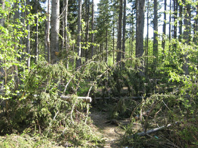
Black Cap Trail trailhead
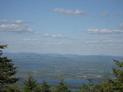
Looking east from the back of Black Cap into Maine
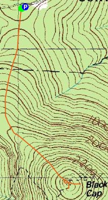

Directions to trailhead: Take Route 16 North from North Conway. Take a right onto Hurricane Mountain Road. Go past the Kearsarge North Trail trailhead, past the gate, and to the top of the mountain. Parking area and trailhead are on the right.
Back to Black Cap Profile
|

