Home
States
Colorado
Connecticut
Maine
Massachusetts
New Hampshire
New York
Rhode Island
Utah
Vermont
View All
Lists
NE 4,000 Footers
NE 100 Highest
NH 4,000 Footers
NH 100 Highest
NH 52 With A View
NH Belknap Range
NH Ossipee 10
Links
Trail Conditions
Trip Log
Sunrises
Sunsets
About
|
Black Cap
Conway, NH
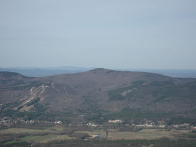
Black Cap as seen from Middle Moat Mountain
 Summary Summary
Black Cap is located east of Cranmore Mountain and south of Hurricane Mountain. There are views in nearly every directions from various points around the ledgy summit. An observation tower was once located near the summit, as late as the 1960s. The western face of the mountain has long been considered for a potential expansion of Cranmore Mountain ski area.
Summit Elevation
2,369 feet
Summit Facilities
None.
Trails
The most popular way to ascend Black Cap is via the Black Cap Trail from Hurricane Mountain Road (closed in winter). A longer route to Black Cap can incorporate the Black Cap Connector Trail from the southwest.
Trip Reports:
Click on the date for photos, timestamps, and maps.
| Date of Hike |
Trail(s) |
Length |
Steepness |
Vertical |
|
| August 29, 2015 |
Black Cap Trail |
Easy |
Moderate |
734' |
| August 31, 2010 |
Black Cap Trail, more |
Easy |
Easy |
754' |
| May 11, 2010 |
Black Cap Trail, more |
Easy |
Easy |
754' |
| April 30, 2010 |
Black Cap Connector |
Moderate |
Moderate |
2,334' |
| November 2, 2009 |
Black Cap Trail |
Easy |
Moderate |
734' |
| November 9, 2008 |
Black Cap Trail |
Easy |
Moderate |
734' |
| August 22, 2007 |
Black Cap Trail |
Easy |
Moderate |
734' |
| May 21, 2007 |
Black Cap Trail |
Easy |
Moderate |
734' |
|
More Information
- Cranmore Mountain Expansion History - Black Cap - NewEnglandSkiHistory.com
- Cranmore Mountain Resort - NewEnglandSkiHistory.com
|
