Home
States
Colorado
Connecticut
Maine
Massachusetts
New Hampshire
New York
Rhode Island
Utah
Vermont
View All
Lists
NE 4,000 Footers
NE 100 Highest
NH 4,000 Footers
NH 100 Highest
NH 52 With A View
NH Belknap Range
NH Ossipee 10
Links
Trail Conditions
Trip Log
Sunrises
Sunsets
About
|
Crotched Mountain
Greenfield, NH, Bennington, NH, Francestown, NH
Trailheads, measurements, times, distances, and maps are all approximate and relative to the hike(s) as shown below.
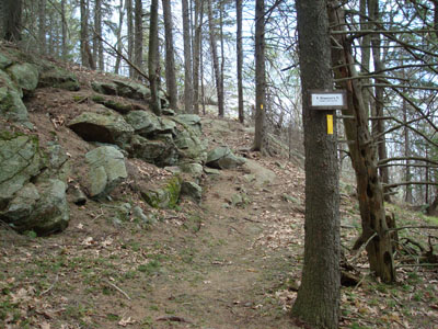
Looking up Shannon's Trail
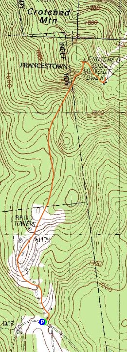
Route: Shannon's Trail, (Crotched Mountain), unknown trail, unknown road, (Crotched Mountain Ski Area summit), unknown road, unknown trail, Shannon's Trail
After hiking Monadnock Mountain in the morning, I decided I'd do another hike in the region, since it's somewhat long drive from home. Since I had wanted to hike Crotched Mountain for years, that was my choice.
Arriving at Shannon's Trail's trailhead, I quickly set off on the trail, which weaves around a big pile of dirt and rocks into a nice, open field on the side of a hill. From there, the trail re-enters the woods, and gently climbs to another field of sorts, near a communications tower. While the trail was well blazed to this point, I was confused by a bunch of unmarked herd paths near the field, none blazed. Fortunately, I had my AMC Southern New Hampshire Guide with me, so I was able to flip to the Crotched Mountain page and read that I should go just to the right of the tower. Thank you.
After passing the tower, the blazes reappear and the trail ducks back into the woods, then eventually down a hill and across a brook.
Beyond the easy brook crossing, the trail starts to climb moderately up Crotched Mountain proper, soon reaching some ledgey vistas, and finally the summit.
The summit isn't anything special - a few communications towers, a few benchmarks (my guess is that the highpoint is near the powerline), and the footings from the old firetower. Though there are some views near the power line, the views are much better at the top of Shannon's Trail, a few dozen vertical feet below the summit.
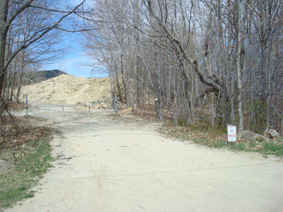
After looking around a little bit, I followed a set of stairs down to a road of sorts, and headed down it, past another tower, to the top of the abandoned ski area. Unfortunately (me being a ski buff), the double chairlift has been recently removed, so there isn't much to see here, other than some concrete and a pile of wood.
On the way down, the clouds overtook the sky above and opened up with some sprinkles briefly. Other than seeing a porcupine off to the side of the trail near the bottom, there was nothing noteworthy about the descent.
| Hike Ratings |
|
Getting To Trailhead: |
Easy |
| Destination: |
Crotched Mountain |
|
Length: |
Moderate |
|
Steepness: |
Moderate |
|
Navigation: |
Moderate |
|
Views: |
Excellent |
|
Crowds: |
Minimal |
|
| Hike Stats |
|
Date Hiked: |
Saturday, April 26, 2008 |
| Hike Commenced: |
2:24 PM |
| Parking Elevation: |
1,305' |
| Destination: |
Crotched Mountain |
| Ascent Commenced: |
2:24 PM |
| Summit Reached: |
3:09 PM |
| Time Elapsed: |
00:45 |
| Trailhead Elevation: |
1,305' |
| Summit Elevation: |
2,066' |
| Distance: |
1.8 miles |
| Vertical Gain: |
871' |
|
|
| Hike Ended: |
4:22 PM |
| Hike Time Elapsed: |
01:58 |
| Hike Vertical Gain: |
1,127' |
|
Shannon's Trail trailhead on Crotched Mountain Road
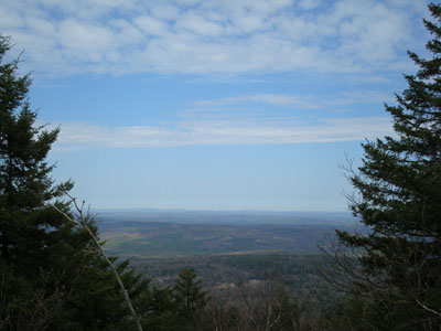
Looking northeast from the summit of Crotched Mountain


Directions to trailhead: Take Route 31 southeast from Bennington. Crotched Mountain Road (not to be confused with Mountain Road) will eventually be on the left. Head up this road to the top of the hill. Just after the first Crotched Mountain entrance way, the trailhead will be on the left (there is a gate next to it). Parking is available on the sides of the road.
Back to Crotched Mountain Profile
|