Home
States
Colorado
Connecticut
Maine
Massachusetts
New Hampshire
New York
Rhode Island
Utah
Vermont
View All
Lists
NE 4,000 Footers
NE 100 Highest
NH 4,000 Footers
NH 100 Highest
NH 52 With A View
NH Belknap Range
NH Ossipee 10
Links
Trail Conditions
Trip Log
Sunrises
Sunsets
About
|
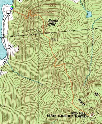
Eagle Cliff, Red Hill
Sandwich, NH, Moultonborough, NH
Trailheads, measurements, times, distances, and maps are all approximate and relative to the hike(s) as shown below.
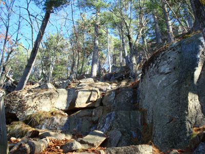
Looking up the cliffs portion of the Eagle Cliff Trail
Route: Eagle Cliff Trail, (Eagle Cliff), Eagle Cliff Trail, (Red Hill), Eagle Cliff Trail, (Eagle Cliff), Eagle Cliff Trail
I felt pretty lazy, so I decided I'd be hiking close to home again. I had originally intended to do the Eagle Cliff Trail to Red Hill as an afterwork hike, however the days were way too short at this point to do so. As a result, I chose this hike as a lazy Sunday afternoon hike.
The Eagle Cliff Trail starts on Squam Lake Road (Bean Road), dipping about five feet into a gully, then gradually ascending for a bit. After a few switchbacks, the trail hits a very rocky area - straight ahead scrambles up the ledges and apparently to the right bypasses them. Despite the fact that the ledges were rather icy, I chose the shorter route. The ice made it a bit tricky, but it was all in good fun.
At the top of the scramble, the bypass trail rejoins. Soon thereafter, the views open up big time, as the trail traverses along some nice ledges on its way to the top of what is known as Eagle Cliff (the topographic maps show it being the highpoint a few tenths of a mile uphill, however the trail signs signal that the scenic cliff is Eagle Cliff). I choose the latter.
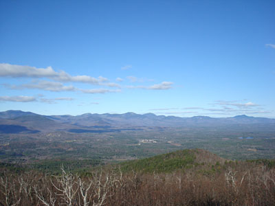
The views from the cliffs are excellent - the Sandwich Range, the Squam Range, and Squam Lake.
After passing Eagle Cliff, the Eagle Cliff Trail continues uphill, then does multiple ups and downs on its way to Red Hill. Since the vertical gain is spread out over the course of nearly two miles, nothing gets overly steep. Personally, I found the ups and downs to be a bit much compared to the more direct Red Hill Trail, but, as Ali G once said, I digest.
As usual, the views from the Red Hill fire tower were excellent - the higher peaks of the Sandwich Range, Mt. Moosilauke, and Mt. Cardigan were all white, while Lake Winnipesaukee and Squam Lake were both a very deep blue.
Oddly enough, the descent seemed to go faster than the ascent. Usually, I find descents to feel long and boring, however the views and good footing made this one seem halfway decent.
| Hike Ratings |
|
Getting To Trailhead: |
Easy |
| Destination: |
Eagle Cliff |
|
Length: |
Easy |
|
Steepness: |
Very Difficult |
|
Navigation: |
Easy |
|
Views: |
Excellent |
|
Crowds: |
Moderate |
| Destination: |
Red Hill |
|
Length: |
Moderate |
|
Steepness: |
Moderate |
|
Navigation: |
Easy |
|
Views: |
Excellent |
|
Crowds: |
Moderate |
|
| Hike Stats |
|
Date Hiked: |
Sunday, November 18, 2007 |
| Hike Commenced: |
12:10 PM |
| Parking Elevation: |
590' |
| Destination: |
Eagle Cliff |
| Ascent Commenced: |
12:10 PM |
| Summit Reached: |
12:31 PM |
| Time Elapsed: |
00:21 |
| Trailhead Elevation: |
580' |
| Summit Elevation: |
1,270' |
| Distance: |
.6 miles |
| Vertical Gain: |
695' |
| Destination: |
Red Hill |
| Ascent Commenced: |
12:33 PM |
| Summit Reached: |
1:22 PM |
| Time Elapsed: |
00:55 |
| Trailhead Elevation: |
1,270' |
| Summit Elevation: |
2,033' |
| Distance: |
1.9 miles |
| Vertical Gain: |
1,113' |
|
|
| Hike Ended: |
2:40 PM |
| Hike Time Elapsed: |
02:30 |
| Hike Distance: |
5 miles |
| Hike Vertical Gain: |
2,173' |
|
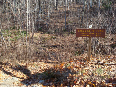
The Eagle Cliff Trail trailhead on Squam Lake Road
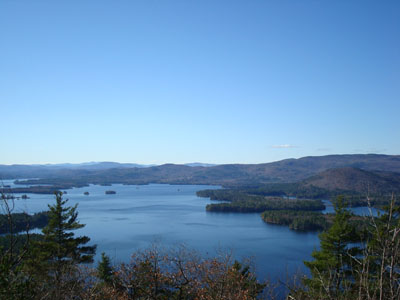
Squam Lake as seen from Eagle Cliff
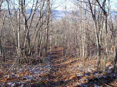
Looking down the Eagle Cliff Trail on the way to the Red Hill summit
Looking northeast at the Sandwich Range (left - Sandwich Dome, center - Mt. Whiteface, Mt. Passaconaway, right - Mt. Chocorua) from the Red Hill fire tower

Directions to trailhead: From Route 113 in Center Sandwich, take Squam Lake Road west. The Eagle Cliff Trail trailhead is just around the corner from where Squam Lake gets close to the road for the second time. Parking available alongside the road.
Back to Eagle Cliff Profile
Back to Red Hill Profile
|


