Home
States
Colorado
Connecticut
Maine
Massachusetts
New Hampshire
New York
Rhode Island
Utah
Vermont
View All
Lists
NE 4,000 Footers
NE 100 Highest
NH 4,000 Footers
NH 100 Highest
NH 52 With A View
NH Belknap Range
NH Ossipee 10
Links
Trail Conditions
Trip Log
Sunrises
Sunsets
About
|
Mt. Crescent
Randolph, NH
Trailheads, measurements, times, distances, and maps are all approximate and relative to the hike(s) as shown below.

The Carlton Notch Trail
Route: Carlton Notch Trail, Crescent Ridge Trail, Mt Crescent Trail, Castleview Loop, Jimtown Logging Road
Trails were mostly dry. Minor mud on Carlton Notch Trail and Castleview Loop. Short section of Jimtown Logging Road between Carlton Notch and Mt. Crescent Trail was very muddy. Bottom of Carlton Notch Trail (between Randolph Road and Mt. Crescent Trail) is filled with broken cars. Poked around briefly, but did not find Boothman Spring Spur on this side.
Foliage is now past peak in Franconia Notch, Twin and Northern Presis, but some nice colors along the trails.
| Hike Ratings |
|
Getting To Trailhead: |
Moderate |
| Destination: |
Mt. Crescent |
|
Length: |
Moderate |
|
Steepness: |
Difficult |
|
Navigation: |
Easy |
|
Views: |
Excellent |
|
Crowds: |
Minimal |
|
| Hike Stats |
|
Date Hiked: |
Friday, October 5, 2012 |
| Parking Elevation: |
630' |
| Destination: |
Mt. Crescent |
| Time Elapsed: |
00:50 |
| Trailhead Elevation: |
1,900' |
| Summit Elevation: |
3,251' |
| Vertical Gain: |
1,401' |
|
|
| Hike Time Elapsed: |
02:02 |
| Hike Vertical Gain: |
1,601' |
|

The Carlton Notch crossing on Randolph Hill Road
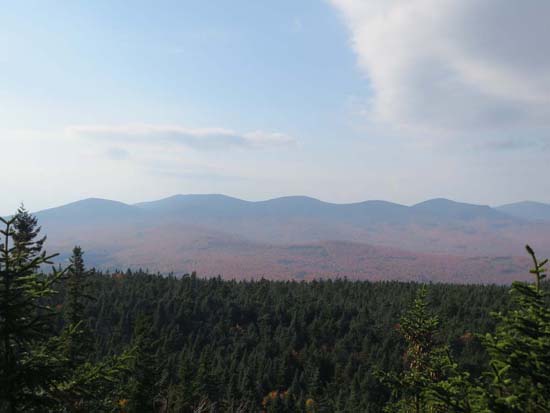
The Weeks as seen from near the summit of Mt. Crescent
Directions to trailhead: Take US 2 west from Gorham to the height of land, then take a right onto Randolph Hill Road. The Carlton Notch Trail crosses the road just prior to its end (at the Jimtown Logging Road).
Back to Mt. Crescent Profile
|

