Home
States
Colorado
Connecticut
Maine
Massachusetts
New Hampshire
New York
Rhode Island
Utah
Vermont
View All
Lists
NE 4,000 Footers
NE 100 Highest
NH 4,000 Footers
NH 100 Highest
NH 52 With A View
NH Belknap Range
NH Ossipee 10
Links
Trail Conditions
Trip Log
Sunrises
Sunsets
About
|
Mt. Osceola (East Peak), Mt. Osceola
Lincoln, NH, Livermore, NH
Trailheads, measurements, times, distances, and maps are all approximate and relative to the hike(s) as shown below.
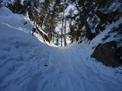
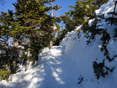
Looking up the Mt. Osceola Trail on the way to Mt. Osceola's East Peak
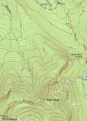
Route: Greeley Ponds Trail, Mt. Osceola Trail, (Mt. Osceola - East Peak), Mt. Osceola Trail, (Mt. Osceola), Mt. Osceola Trail, (Mt. Osceola - East Peak), Mt. Osceola Trail, Greeley Ponds Trail
Not wanting to let an awesome springlike day go to waste, I headed out a few hours early to the Osceolas. The Greeley Ponds Trail was a borderline disaster - the recent storm had knocked all sorts of branches and trees over the trail, resulting in a maze of herd paths. While it was Presidential weather, East Osceola provided some nice views - due to the snowpack, there was a tremendous northwestern view a dozen feet from the highpoint.
Between the peaks, the chimney was still filled in with snow, though the bypass was a bit easier due to the higher (due to snowpack) starting point. From the summit of Osceola, the views were strong as well - a little more snow and they'd be 360 degrees.
Descending off East Osceola, the trail was a bit tough - the spring snow was setting up, and the trail was beat up from barebooters and buttsliders. Nonetheless, I was able to make it back before sunset.
| Hike Ratings |
|
Getting To Trailhead: |
Easy |
| Destination: |
Mt. Osceola (East Peak) |
|
Length: |
Moderate |
|
Steepness: |
Very Difficult |
|
Navigation: |
Moderate |
|
Views: |
Excellent |
|
Crowds: |
Minimal |
| Destination: |
Mt. Osceola |
|
Length: |
Moderate |
|
Steepness: |
Very Difficult |
|
Navigation: |
Easy |
|
Views: |
Excellent |
|
Crowds: |
Minimal |
|
| Hike Stats |
|
Date Hiked: |
Wednesday, March 10, 2010 |
| Hike Commenced: |
1:12 PM |
| Parking Elevation: |
1,940' |
| Destination: |
Mt. Osceola (East Peak) |
| Ascent Commenced: |
1:12 PM |
| Summit Reached: |
2:41 PM |
| Time Elapsed: |
01:29 |
| Trailhead Elevation: |
1,940' |
| Summit Elevation: |
4,156' |
| Distance: |
2.8 miles |
| Vertical Gain: |
2,331' |
| Destination: |
Mt. Osceola |
| Ascent Commenced: |
2:41 PM |
| Summit Reached: |
3:13 PM |
| Time Elapsed: |
00:32 |
| Trailhead Elevation: |
4,156' |
| Summit Elevation: |
4,340' |
| Distance: |
1 mile |
| Vertical Gain: |
560' |
|
|
| Hike Ended: |
5:10 PM |
| Hike Time Elapsed: |
03:58 |
| Hike Distance: |
7.6 miles |
| Hike Vertical Gain: |
3,392' |
|
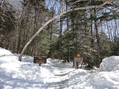
The Greeley Ponds Trail trailhead
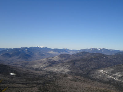
Looking into the Pemi from near the summit of Mt. Osceola
The Mt. Osceola Trail between the peaks
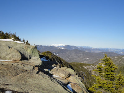
Looking at Mt. Washington from the Mt. Osceola ledges

Directions to trailhead: Take Route 112 west from Conway. After passing the Hancock Trail trailhead and parking lot, the Greeley Ponds trailhead and WMNF fee parking area will be on the left a few minutes later.
Back to Mt. Osceola (East Peak) Profile
Back to Mt. Osceola Profile
|