Home
States
Colorado
Connecticut
Maine
Massachusetts
New Hampshire
New York
Rhode Island
Utah
Vermont
View All
Lists
NE 4,000 Footers
NE 100 Highest
NH 4,000 Footers
NH 100 Highest
NH 52 With A View
NH Belknap Range
NH Ossipee 10
Links
Trail Conditions
Trip Log
Sunrises
Sunsets
About
|
Mt. Major, Straightback Mountain
Alton, NH
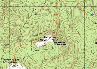
Trailheads, measurements, times, distances, and maps are all approximate and relative to the hike(s) as shown below.
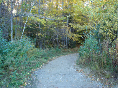
Looking down the Mt. Major Trail
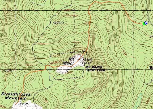
Route: Mt. Major Trail, (Mt. Major), Major/Straightback Link, (Straightback Mountain), Major/Straightback Link, (Mt. Major), Mt. Major Trail
I had been itching to get back to Mt. Major for quite awhile - my first trip up it was just after Thanksgiving in 2006 and from that day, I had wanted to visit again.
With the days quickly getting shorter, I knew I was working with limited daylight. Arriving at the trailhead just after 4, I started the easy to moderate initial ascent up the Mt. Major Trail. This first section is essentially an old dirt road - a bit rocky at first, but then pretty flat with good footing.
At what ends up being just about the halfway point, the Mt. Major Trail veers off to the left and starts a moderate climb. Soon thereafter, things steepen up, as the trail heads up multiple ledges (there is a marked detour around these). This is a fun section of trail, both with the terrain and the views that start to emerge.
Once at the summit, I was greeted with excellent views - surprising, considering I've found the views in this area to generally be hazy when the temperature is near 80 (such as it was when I started).
Though somewhat busy, the hike to this point wasn't overwhelming - but I can imagine this would not be a fun place on a nice weekend day due to its popularity.
After loitering around the summit for awhile and seeing that there was still some sunlight left, I decided to head over to Straightback Mountain. I had initially intended to hike this a year earlier, however a combination of time and not knowing exactly where the trail was prevented this. The trail is actually pretty easy to find - continue follow the blue blazes over the summit. The Brook Trail eventually breaks off to the right, after about .4 miles of nice ledge walking.
From the Brook Trail junction, the Major/Straightback Link trail is noticably less travelled than the other trails around Mt. Major. Though nowhere as scenic as the Mt. Major Trail, there still are a few view points from ledges on the trail.
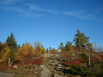
Soon, I arrived at the flat, open summit - it's covered by rocks, low bush blueberry vines, and small sapplings. The views are nice too - looking south and west - though nowhere near as good as those from Mt. Major.
Looking over at the sun (but not directly of course, I don't want get a seeing eye dog), I realized the sunset was minutes away. As a result, I decided not to loiter here too long.
I arrived back at an empty (wow!) Mt. Major summit just in time for the tail end of the sunset. While the sunset itself wasn't overly great (as it, at this time of the year, sets over the nearby mountains), the clouds over the lake provided some nice colours.
Once the awesome display was over, I put on my headlamp and headed back down the Mt. Major Trail, pausing on the ledges to see the neat views of the Wolfeboro lights reflecting on Lake Winnipesaukee.
Though not a place for solitude, Mt. Major is a great hike!
| Hike Ratings |
|
Getting To Trailhead: |
Easy |
| Destination: |
Mt. Major |
|
Length: |
Moderate |
|
Steepness: |
Difficult |
|
Navigation: |
Easy |
|
Views: |
Excellent |
|
Crowds: |
Heavy |
| Destination: |
Straightback Mountain |
|
Length: |
Moderate |
|
Steepness: |
Moderate |
|
Navigation: |
Easy |
|
Views: |
Excellent |
|
Crowds: |
Minimal |
|
| Hike Stats |
|
Date Hiked: |
Monday, October 22, 2007 |
| Hike Commenced: |
4:13 PM |
| Parking Elevation: |
585' |
| Destination: |
Mt. Major |
| Ascent Commenced: |
4:13 PM |
| Summit Reached: |
4:49 PM |
| Time Elapsed: |
00:36 |
| Trailhead Elevation: |
600' |
| Summit Elevation: |
1,786' |
| Distance: |
1.75 miles |
| Vertical Gain: |
1,211' |
| Destination: |
Straightback Mountain |
| Ascent Commenced: |
4:56 PM |
| Summit Reached: |
5:20 PM |
| Time Elapsed: |
00:24 |
| Trailhead Elevation: |
1,786' |
| Summit Elevation: |
1,890' |
| Distance: |
1.1 miles |
| Vertical Gain: |
365' |
|
|
| Hike Ended: |
6:49 PM |
| Hike Time Elapsed: |
02:36 |
| Hike Distance: |
5.7 miles |
| Hike Vertical Gain: |
1,877' |
|
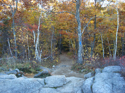
The Mt. Major Trail trailhead at the back of the Route 11 parking lot

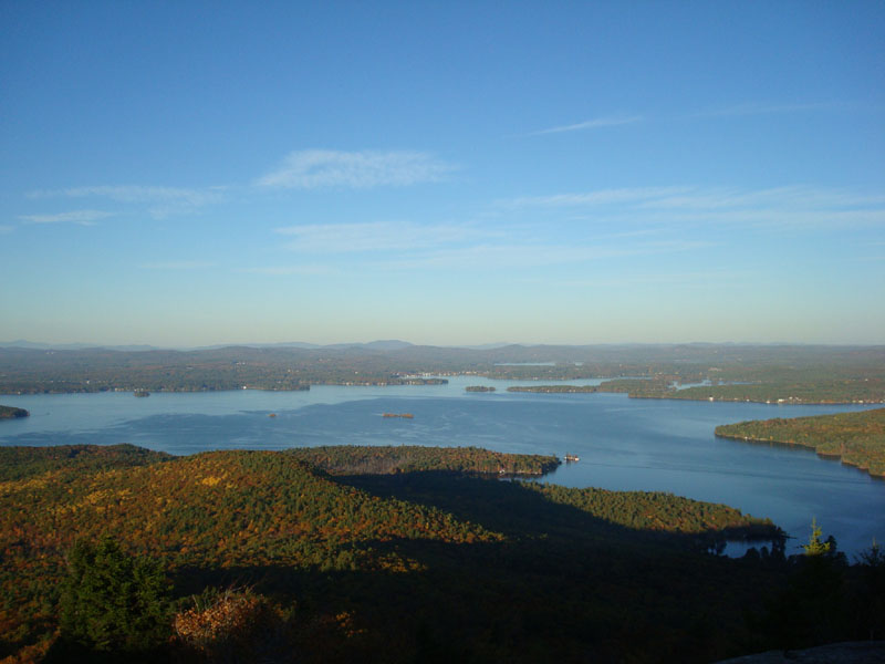
Looking over Lake Winnipesaukee at Wolfeboro from the Mt. Major summit
Looking back toward Mt. Major while on the Major/Straightback Link trail to Straightback Mountain

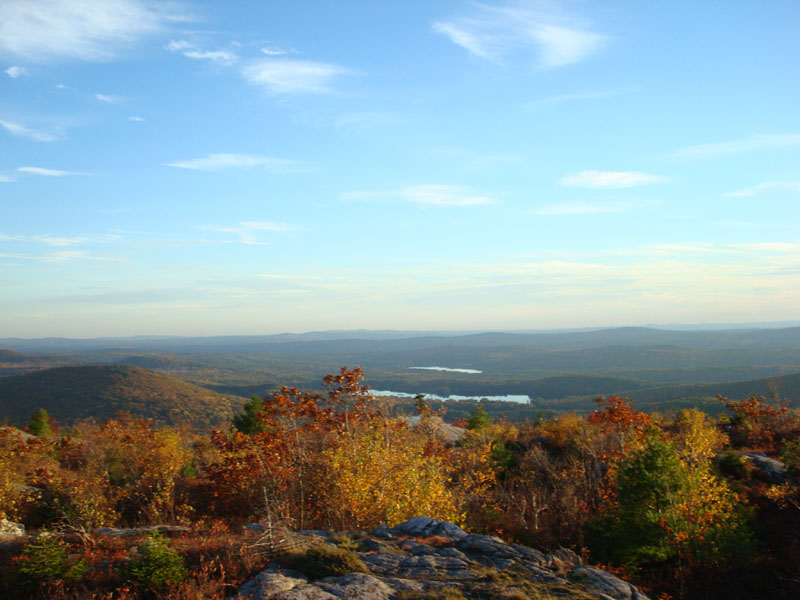
Looking south at Crystal Lake and Sunset Lake from the Straightback Mountain summit

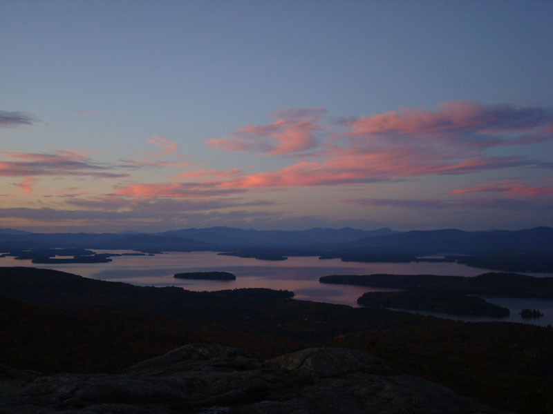
Looking out over Lake Winnipesaukee at sunset from the Mt. Major summit

Directions to trailhead: Take Route 11 West (north in reality) from Alton Bay. Parking lot and trailhead are on the left after the blasted out section of Route 11.
Back to Mt. Major Profile
Back to Straightback Mountain Profile
|