Home
States
Colorado
Connecticut
Maine
Massachusetts
New Hampshire
New York
Rhode Island
Utah
Vermont
View All
Lists
NE 4,000 Footers
NE 100 Highest
NH 4,000 Footers
NH 100 Highest
NH 52 With A View
NH Belknap Range
NH Ossipee 10
Links
Trail Conditions
Trip Log
Sunrises
Sunsets
About
|
Mt. Monroe, Mt. Washington
Chandler's Purchase, NH, Sargent's Purchase, NH, Thompson and Meserve's Purchase, NH
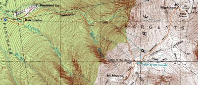
Trailheads, measurements, times, distances, and maps are all approximate and relative to the hike(s) as shown below.
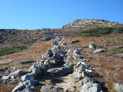
Looking up the Monroe Loop Trail
Route: Ammonoosuc Ravine Trail, Mount Monroe Loop, (Mt. Monroe), Mount Monroe Loop, Crawford Path, (Mt. Washington), Crawford Path, Ammonoosuc Ravine Trail
For quite awhile I had been hoping to give Mt. Monroe and Mt. Washington a try in the fall. With some early winter weather a week earlier, I figured my chances were slim. Fortunately, some warmer weather moved in and melted the minimal accumulations of ice and snow.
Since the early morning forecast showed Mt. Washington being in the fog for the morning, I took my time in getting up to Crawford Notch. I was a bit concerned to see that all of the summits, even Webster, were in fog.
The flats along the Ammonoosuc Ravine Trail went fairly quickly - the brisk temperatures helped to keep me cool. As I ascended, I could see the slopes of Mt. Washington and Mt. Monroe were in the clear.
I saw a small patch of snow just past the Lakes of Clouds hut, a sign of things to come. As I reached the top of the Monroe ridge, I was bombarded by cold, heavy winds. Wanting to keep my momentum going, I didn't loiter for long.
Back at the boarded up Lakes of the Clouds Hut, there was a small crowd building up, seemingly waiting for someone to start the ascent into the on and off clouds of Mt. Washington. I stopped here for a quick snack and to bundle up, but was soon on my way.
The winds along the Crawford Path weren't too bad, that is until I reached the shoulder where the trail makes its final turn toward the summit. Here, the rocks were covered in rime and the wind was whipping. Soon, I was at the summit area, and amongst a bunch of bundled up, non-English speaking folks who had hitched a ride on the Cog or auto road. After sneaking over the highpoint in between the photo taking sessions, I headed to the cafeteria.
Once again, busy busy. I had to weave my way through the restroom line just to get into the actual cafeteria seating area. Nonetheless, it was worth it, as there are very few peaks in the White Mountains at which one can obtain hot food and beverage. Since the summit was in the clouds for the most part, I took my time in the building, finally bundling up and heading out to take a few quick photos during a brief lapse of moisture. After that, I made my way down the Crawford Path, passing a bunch of folks who finally were ascending.
Back at the hut, there were dozens of folks hanging out, many of them contemplating whether or not to continue up. I stopped here again, this time to remove some layers and get ready for the final descent.
The Ammonoosuc Ravine Trail at this point was rather busy, as I passed a bunch of folks who, by their attire and their questions of 'how much longer until I reach the top' when they were nowhere near even the hut, didn't seem to be prepared for a fall-in-name-only-hike.
Nonetheless, it was a nice day to be in the Presidentials.
| Hike Ratings |
|
Getting To Trailhead: |
Easy |
| Destination: |
Mt. Monroe |
|
Length: |
Moderate |
|
Steepness: |
Difficult |
|
Navigation: |
Easy |
|
Views: |
Excellent |
|
Crowds: |
Heavy |
| Destination: |
Mt. Washington |
|
Length: |
Difficult |
|
Steepness: |
Difficult |
|
Navigation: |
Easy |
|
Views: |
Excellent |
|
Crowds: |
Heavy |
|
| Hike Stats |
|
Date Hiked: |
Saturday, October 11, 2008 |
| Hike Commenced: |
8:27 AM |
| Parking Elevation: |
2,500' |
| Destination: |
Mt. Monroe |
| Ascent Commenced: |
8:27 AM |
| Summit Reached: |
10:09 AM |
| Time Elapsed: |
01:42 |
| Trailhead Elevation: |
2,500' |
| Summit Elevation: |
5,372' |
| Distance: |
3.5 miles |
| Vertical Gain: |
2,972' |
| Destination: |
Mt. Washington |
| Ascent Commenced: |
10:14 AM |
| Summit Reached: |
11:17 AM |
| Time Elapsed: |
01:03 |
| Trailhead Elevation: |
5,372' |
| Summit Elevation: |
6,288' |
| Vertical Gain: |
1,301' |
|
|
| Hike Ended: |
2:59 PM |
| Hike Time Elapsed: |
06:32 |
| Hike Vertical Gain: |
4,378' |
|
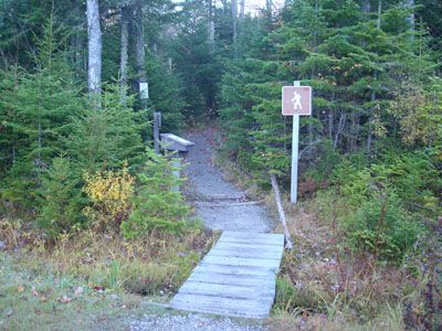
The Ammonoonusc Ravine Trail trailhead at the edge of the parking area
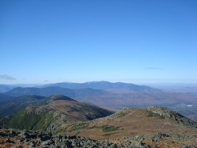
Looking at the Southern Presidentials, and in the distance, the Franconia Ridge from the summit of Mt. Monroe

Looking up the Crawford Path near the summit of Mt. Washington

Looking at the Carters and Wildcats from Washington

Directions to trailhead: Take Route 302 West from Bartlett up to Crawford Notch. Take a right onto Clinton Road. Follow the road to Base Road (stop sign). Take a right, then take a right a few minutes thereafter into the hiker parking area. The trailhead is on the eastern side of the parking lot.
Back to Mt. Monroe Profile
Back to Mt. Washington Profile
|