Home
States
Colorado
Connecticut
Maine
Massachusetts
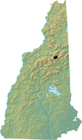
New Hampshire
New York
Rhode Island
Utah
Vermont
View All
Lists
NE 4,000 Footers
NE 100 Highest
NH 4,000 Footers
NH 100 Highest
NH 52 With A View
NH Belknap Range
NH Ossipee 10
Links
Trail Conditions
Trip Log
Sunrises
Sunsets
About
|
Mt. Monroe
Sargent's Purchase, NH
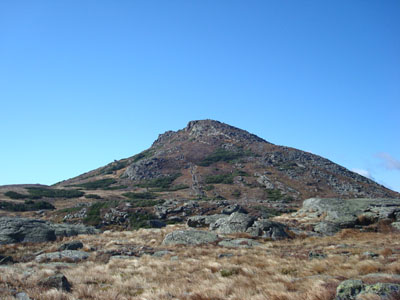
Mt. Monroe as seen from near the Lakes of the Clouds
 Summary Summary
Named after President James Monroe, Mt. Monroe is located between Mt. Eisenhower and Mt. Washington. The rocky summit features views in all directions. The seasonal Lakes of the Clouds hut is located a fraction of a mile from Monroe's summit.
Summit Elevation
5,372 feet
Summit Facilities
None.
Trip Reports:
Click on the date for photos, timestamps, and maps.
| Date of Hike |
Trail(s) |
Length |
Steepness |
Vertical |
|
| April 24, 2021 |
Ammonoosuc Ravine Trail, more |
Difficult |
Difficult |
5,205' |
| March 7, 2021 |
Valley Way, more |
Difficult |
Very Difficult |
7,952' |
| January 1, 2021 |
Ammonoosuc Ravine Trail, more |
Difficult |
Difficult |
5,205' |
| October 22, 2020 |
Ammonoosuc Ravine Trail, more |
Moderate |
Difficult |
4,073' |
| September 13, 2019 |
Ammonoosuc Ravine Trail, more |
Moderate |
Difficult |
2,862' |
| May 18, 2019 |
Cog Rail Trail, more |
Difficult |
Very Difficult |
6,395' |
| December 1, 2018 |
Ammonoosuc Ravine Trail, more |
Difficult |
Difficult |
5,205' |
| November 18, 2018 |
Ammonoosuc Ravine Trail, more |
Moderate |
Difficult |
4,073' |
| August 24, 2017 |
Huntington Ravine Trail, more |
Difficult |
Very Difficult |
5,296' |
| February 22, 2017 |
Valley Way, more |
Difficult |
Very Difficult |
7,952' |
| June 14, 2015 |
Ammonoosuc Ravine Trail, more |
Moderate |
Difficult |
4,298' |
| August 19, 2014 |
Ammonoosuc Ravine Trail, more |
Moderate |
Difficult |
2,862' |
| July 27, 2013 |
Tuckerman Ravine Trail, more |
Difficult |
Very Difficult |
5,341' |
| February 29, 2012 |
Ammonoosuc Ravine Trail, more |
Moderate |
Very Difficult |
4,343' |
| August 11, 2011 |
Ammonoosuc Ravine Trail, more |
Moderate |
Difficult |
3,902' |
| July 24, 2011 |
Ammonoosuc Ravine Trail, more |
Moderate |
Difficult |
3,932' |
| December 26, 2010 |
Ammonoosuc Ravine Trail, more |
Difficult |
Very Difficult |
5,098' |
| September 1, 2010 |
Boott Spur Trail, more |
Difficult |
Very Difficult |
5,448' |
| May 5, 2010 |
Ammonoosuc Ravine Trail, more |
Difficult |
Very Difficult |
5,595' |
| January 14, 2010 |
Ammonoosuc Ravine Trail, more |
Difficult |
Difficult |
5,205' |
| December 31, 2009 |
Ammonoosuc Ravine Trail, more |
Difficult |
Very Difficult |
5,048' |
| November 22, 2009 |
Jewell Trail, more |
Difficult |
Very Difficult |
5,098' |
| April 19, 2009 |
Ammonoosuc Ravine Trail, more |
Difficult |
Very Difficult |
5,048' |
| March 25, 2009 |
Jewell Trail, more |
Difficult |
Very Difficult |
4,398' |
| February 25, 2009 |
Ammonoosuc Ravine Trail, more |
Difficult |
Difficult |
2,862' |
| October 11, 2008 |
Ammonoosuc Ravine Trail, more |
Difficult |
Difficult |
4,378' |
| August 22, 2008 |
Ammonoosuc Ravine Trail, more |
Difficult |
Difficult |
4,746' |
| June 25, 2008 |
Ammonoosuc Ravine Trail, more |
Moderate |
Difficult |
3,102' |
| July 3, 2007 |
Edmands Path, more |
Difficult |
Difficult |
4,314' |
|
More Information
- New Hampshire 4,000 Foot Peaks
- New England 4,000 Foot Peaks
- New England 100 Highest Peaks
- James Monroe - Wikipedia - the mountain's namesake
|
