Home
States
Colorado
Connecticut
Maine
Massachusetts
New Hampshire
New York
Rhode Island
Utah
Vermont
View All
Lists
NE 4,000 Footers
NE 100 Highest
NH 4,000 Footers
NH 100 Highest
NH 52 With A View
NH Belknap Range
NH Ossipee 10
Links
Trail Conditions
Trip Log
Sunrises
Sunsets
About
|
Mt. Monroe, Mt. Washington
Chandler's Purchase, NH, Sargent's Purchase, NH
Trailheads, measurements, times, distances, and maps are all approximate and relative to the hike(s) as shown below.

Ascending near the Ammonoosuc Ravine Trail near the Lakes of Clouds hut
Route: Ammonoosuc Ravine Trail, snowfield, (Mt. Monroe), snowfield, Crawford Path, snowfield, (Mt. Washington), snowfield, Cog Railway Trail
If you're up in this part of the Presis right now without snowshoes, you should be responsible for paying your rescue expenses.
Ammo up to the pool was bony in places with some slush. We were able to snowshoe, but one could boot this stretch. Snow is about a foot deep up to this point. Once the ascent starts, the snow depth increases. There has been enough recent snow to cover the ice and most of the rock, assuming it didn't get trashed later in the day. Nearing treeline, the packed route deviates from the trail and soon there are a bunch of different routes, not well packed. Our tracks stayed kosher for the approach to the hut, whereas others were going around the other side.
Unfortunately, there were some barebooters without any snowshoes who were making a mess (both by postholing and by urinating on the trail). One commented that it was "dangerous" due to the snow depths. Also got a bunch of second hand smoke from someone hiking with smoking cigarettes.
The snowpack on this side is already nearing mid winter depths in places. We were able to pretty close to beeline from the hut to Monroe without trampling vegetation.
The initial Crawford Path route from the hut is way off, with barebooters walking up the shore of one of the lakes. We followed the actual trail with snowshoes. The sideslope has already set up...the snowpack is currently grippy enough to get across, but there is no established shelf/footbed, making this potentially dangerous if we get any ice (Tuckerman Crossover avoids this no fall zone).
Climbing the cone, the deep postholes were very vexing, so we once again took a snowfield beeline to the towers. Plenty of snowpack.
From the summit, we cut down snowfields to the cog rail. We took the trail on the north side of the track, which generally gradual (a couple of no fall zones above treeline). A few areas of thin base with rocks poking through, but it had been skied today. Unfortunately, it was also postholed. Near the bottom, there is an underpass to get onto the southern side of the tracks and then down to the bridge. My first time descending this way; very pleasant. The cog is currently running for a few more weeks up to 3,800 feet.
Decent weather today. Chilly winds on Monroe and Washington, but still less than 20 mph. Felt like mid winter.
| Hike Ratings |
|
Getting To Trailhead: |
Easy |
| Destination: |
Mt. Monroe |
|
Length: |
Moderate |
|
Steepness: |
Difficult |
|
Navigation: |
Easy |
|
Views: |
Excellent |
|
Crowds: |
Heavy |
| Destination: |
Mt. Washington |
|
Length: |
Moderate |
|
Steepness: |
Difficult |
|
Navigation: |
Easy |
|
Views: |
Excellent |
|
Crowds: |
Heavy |
|
| Hike Stats |
|
Date Hiked: |
Sunday, November 18 |
| Parking Elevation: |
2,700' |
| Destination: |
Mt. Monroe |
| Time Elapsed: |
02:36 |
| Trailhead Elevation: |
2,740' |
| Summit Elevation: |
5,372' |
| Vertical Gain: |
2,732' |
| Destination: |
Mt. Washington |
| Time Elapsed: |
01:50 |
| Trailhead Elevation: |
5,372' |
| Summit Elevation: |
6,288' |
| Vertical Gain: |
1,301' |
|
|
| Hike Time Elapsed: |
06:31 |
| Hike Vertical Gain: |
4,073' |
|

The trailhead near the Marshfield Base Station

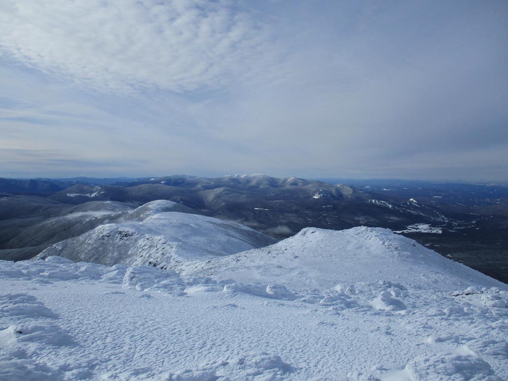
Looking at the Southern Presidentials from Mt. Monroe

The Crawford Path on the way to Mt. Washington

Looking at the Carters and Wildcats from Mt. Washington

The Cog Railway Trail
Directions to trailhead: To get to the Cog Base Station, take 302 West from Crawford Notch, then take a right onto Base Station Road. In winter 2018-19, there was hiker parking available at the Cog Base Station's bottom lot for $10. Looking up the mountain from the parking lot, the spur trail to the Ammonoosuc Ravine Trail begins up the hill to the right, a bit below two cabins.
Back to Mt. Monroe Profile
Back to Mt. Washington Profile
|