Home
States
Colorado
Connecticut
Maine
Massachusetts
New Hampshire
New York
Rhode Island
Utah
Vermont
View All
Lists
NE 4,000 Footers
NE 100 Highest
NH 4,000 Footers
NH 100 Highest
NH 52 With A View
NH Belknap Range
NH Ossipee 10
Links
Trail Conditions
Trip Log
Sunrises
Sunsets
About
|
Mt. Monroe
Chandler's Purchase, NH, Sargent's Purchase, NH
Trailheads, measurements, times, distances, and maps are all approximate and relative to the hike(s) as shown below.
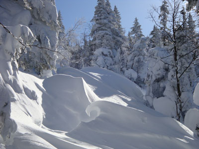
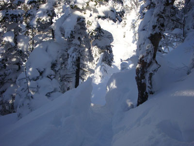
Looking up the Ammonoosuc Ravine Trail
Route: Unknown trail, Ammonoosuc Ravine Trail, Mount Monroe Loop, (Mt. Monroe), Mount Monroe Loop, Ammonoosuc Ravine Trail, unknown trail
After skipping Mt. Monroe just over a week earlier due to running out of time during a traverse, I wanted to get back and reach the summit for the first time in winter. Arriving at the Marshfield Base Station, I was a bit concerned to see the Ammonoousc Trail hadn't been touched since the last snowstorm. Even more concerning was that, as I started my way up to the trailhead, I was sinking up to my knees in powder - despite wearing snowshoes! Fortunately, some other hikers showed up, so this major trailbreaking operation was still a realistic possibility.
It took over an hour and a half just to reach the Gem Pool. Considering this is very level terrain, we knew we'd have a heck of a time with the steeper terrain above it. Up to this point, the snow was averaging between knee and hip deep.
Above the Gem Pool, our progress slowed even more. In some drifted areas, I was up to my shoulders in powder. Perhaps a neat thing on skis, but not so neat while trying to ascend on snowshoes.
Though I had been on this trail multiple times before, I found it a bit hard to follow in some places, due to the drifting and some blowdowns. As we cleared the trees, we realized it would be just about impossible to follow the actual trail (winter or summer version), so we aimed for more solid, drifted snow - finally, a bit of a break from trailbreaking! As we neared the hut, we could see some old snowshoe and crampon tracks, so we followed those as to be consistent with what was there days earlier.
The snow was dramatically drifted at the hut. While the drift a week earlier led up the roof, this time pretty much the entire front of the hut was a large snowbank. Amazing!
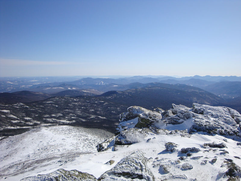
Seeing that the snow was blown away beyond this point, we switched to crampons and made our way up Monroe. A combination of patches of blue ice and a tricky sidehill section made it a bit less easy than normal, however we were soon on the summit enjoying nice views. I was particularly impressed to see the white alpine zone of Mt. Mansfield to the west and the ski trails of Gunstock to the south.
Back at the hut, we enjoyed the relatively mild weather before heading back down the trail. While we ascended at a very slow pace, we made decent time back, thanks to the nicely packed trail.
| Hike Ratings |
|
Getting To Trailhead: |
Easy |
| Destination: |
Mt. Monroe |
|
Length: |
Difficult |
|
Steepness: |
Difficult |
|
Navigation: |
Difficult |
|
Views: |
Excellent |
|
Crowds: |
Moderate |
|
| Hike Stats |
|
Date Hiked: |
Wednesday, February 25, 2009 |
| Hike Commenced: |
8:29 AM |
| Parking Elevation: |
2,700' |
| Destination: |
Mt. Monroe |
| Ascent Commenced: |
8:33 AM |
| Summit Reached: |
1:39 PM |
| Time Elapsed: |
05:06 |
| Trailhead Elevation: |
2,740' |
| Summit Elevation: |
5,372' |
| Vertical Gain: |
2,732' |
|
|
| Hike Ended: |
4:00 PM |
| Hike Time Elapsed: |
07:31 |
| Hike Vertical Gain: |
2,862' |
|
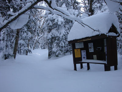
The trailhead near the Marshfield Base Station
Looking down the Ammonoosuc Ravine Trail

Looking southeast from the Mt. Monroe summit

Directions to trailhead: To get to the Cog Base Station in winter, take 302 West from Crawford Notch, then take a right onto Base Station Road. In winter 2008-09, there was plowed parking available at the Cog Base Station. Looking up the mountain from the parking lot, the spur trail to the Ammonoosuc Ravine Trail begins up the hill to the right, a bit below two cabins.
Back to Mt. Monroe Profile
|