Home
States
Colorado
Connecticut
Maine
Massachusetts
New Hampshire
New York
Rhode Island
Utah
Vermont
View All
Lists
NE 4,000 Footers
NE 100 Highest
NH 4,000 Footers
NH 100 Highest
NH 52 With A View
NH Belknap Range
NH Ossipee 10
Links
Trail Conditions
Trip Log
Sunrises
Sunsets
About
|
Zealand Mountain, Mt. Guyot, Mt. Bond (West Peak), Mt. Bond, Bondcliff
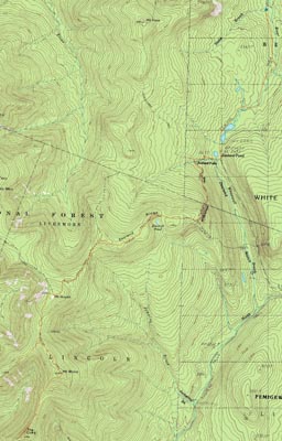
Bethlehem, NH, Livermore, NH, Lincoln, NH
Trailheads, measurements, times, distances, and maps are all approximate and relative to the hike(s) as shown below.
Though a bit dull, the Zealand Trail is 100X more exciting than the Lincoln Woods trail
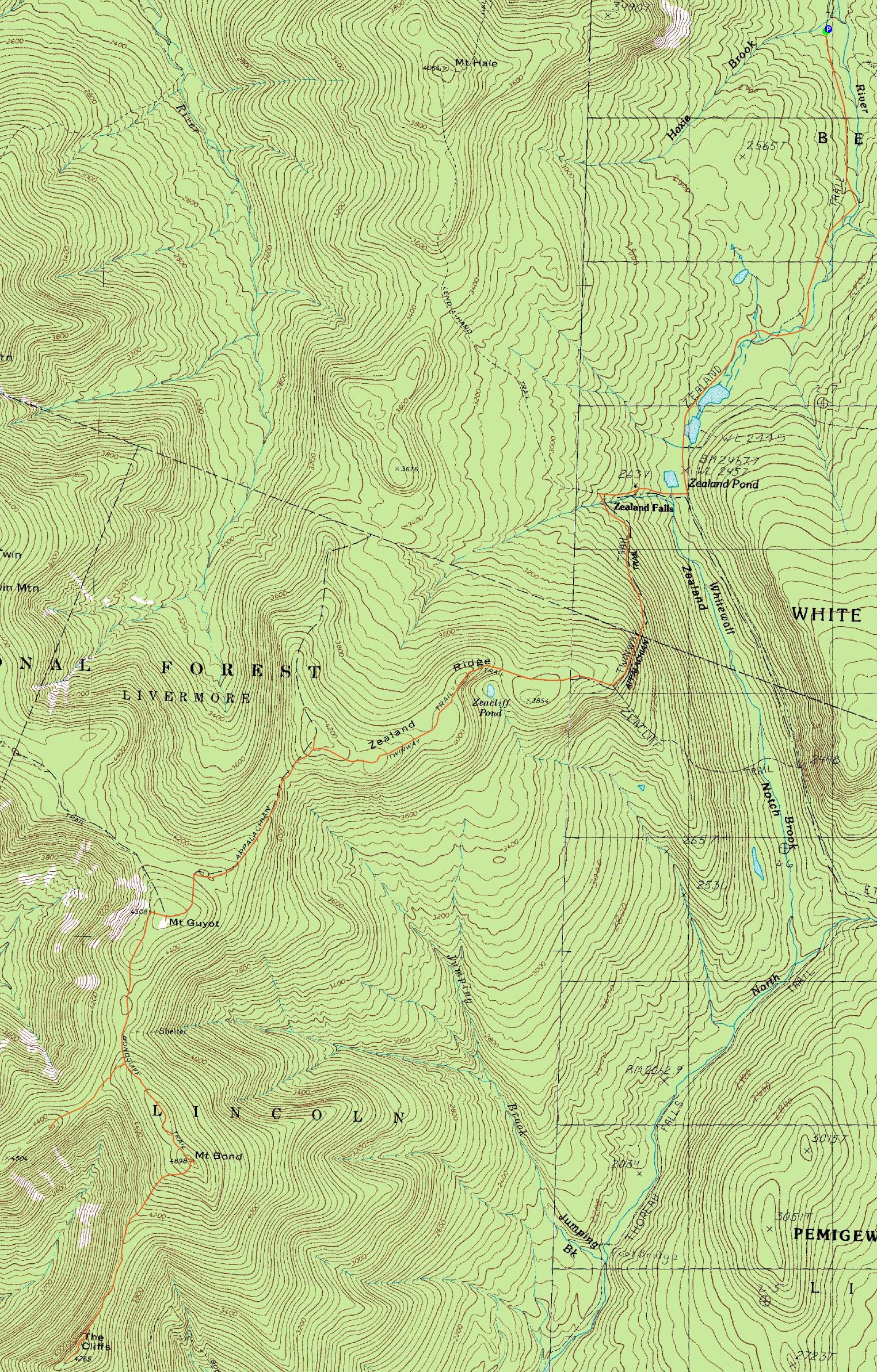
Route: Zealand Trail, Twinway, spur trail, (Zealand Mountain), spur trail, Twinway, (Mt. Guyot), Twinway, Bondcliff Trail, West Bond Trail, (West Bond), West Bond Trail, Bondcliff Trail, (Mt. Bond), Bondcliff Trail, (Bondcliff), Bondcliff Trail, (Mt. Bond), Bondcliff Trail, Twinway, (Mt. Guyot), Twinway, Zealand Trail
It was finally time to attempt the Bonds. I had originally planned this hike for June 2007, however a knee injury intervened. I had then planned to try it as a spring hike, but then a back injury intervened. Finally, I was ready to go on June 7th, however a combination of a lack of sleep and a poor weather forecast cancelled those plans.
After weeks of poor weather, a nice forecast came through for the 4th of July. As a result of it, I started to ramp up my preparations (adjusting my sleep schedule for an earlier wake up, studying routes, etc.).
Arriving at the Zealand Trail trailhead right on schedule, I started a brisk walk. Knowing that much of the trail is flat railgrade with decent footing (save for a few reroutes), I was determined to get to the hut within an hour. I beat my goal slightly, passing the hut at 6:55. Surprisingly, despite going around some marshes and ponds, there were no mosquitoes to speak of.
Shortly after the water crossings above the hut, the Twinway Trail steepened up, maintaining a decent pitch until clearing the top of the ridge. Since I had gazelle intensity going, I didn't bother checking out the Zeacliff viewpoint, and instead continued up the Twinway Trail, as it lollygagged its way to Zealand Mountain.
As I arrived at what I thought was the height of land (after passing a few false peaks), I was wondering where the summit spur trail was - concerned that perhaps I had walked right by it, I saw it a few steps later, as I was starting to descend toward Guyot. Marked by a makeshift sign, it was hard to miss.
I dropped my back and followed the spur path to the true summit, marked by a cairn and sign, basked in the anticlimaticism of it all, then turned around and headed out, eager to find some views. Other than some view points much earlier in the hike, as well as some looks down the trail, there wasn't much at all to see on Zealand.
My next stop was Guyot. The section of trail between Zealand and Guyot was perhaps the roughest of the hike, sporting a steep drop off Zealand and a few sections of rocky footing. Nonetheless, I was soon emerging into an alpine zone and seeing some great views.
While the summit of Guyot had some great views, perhaps even better views were from it's southern summit on the Bondcliff Trail. The section of trail between Guyot's highpoint and the Bondcliff Trail south of the south summit could easily fit into the southern Presidentials, in terms of look and feel.
Again not wanting to waste time, I headed to the West Bond trail junction. After a few up and downs, I was there. Dropping pack and grabbing a Vitamin Water (the only flavored beverage I had with me), I quickly headed down into the col and then up to the highpoint of West Bond. Thought a little steep near the top, much of the trail is fairly gradual.
The views from the small summit were excellent - all throughout the Pemi. Shortly after summitting, I saw one of the first hikers of the day, an AT through hiker who had decided to do an NH 4K detour after spending the night at the Guyot camp sight. After chatting a bit, I decided to get going.
Picking up my pack at the junction with refreshed shoulders, I continued the ascent up to the top of Mt. Bond. Though the views from the top were tremendous, I personally enjoyed the views from South Guyot, West Bond, (and Bondcliff) more due to the openess of those summit. Since I still had a lot more hiking left to do, I quickly continued on my way down the Bondcliff Trail.
A bit steep and rocky, the trail soon emerged from the trees, resulting in spectacular scenery. As I hit the topographical low point, I dropped my back, grabbed my Vitamin Water, and headed to the highpoint (which is just a bit beyond the heavily photographed ledge).
The views from the cliffs and everywhere around them were spectacular. If I wasn't in such a rush, I could have spent hours taking in the sights. Nonetheless, I knew I had three decent ascents in front of me still - getting back to Bond, then Guyot, then Zealand.
As I reascended Bond, I could tell it was definitely past time for lunch (and that, with the sun beating down on me, it was getting hot). up until this point, I had only eaten a few pancakes before I drove up and then a peanut butter Twix bar on Zealand. Arriving back on the summit of Mt. Bond, I took off my hiking shoes and had some pasta and a sandwich. I was going to eat some additional snacks while there, however an increasing number of wasps were hanging out at the top of the small trees around me, making me concerned about having food out. Once the visible number of them approached and passed half a dozen, I decided it was time to get going.
As I backtracked my way back to Zealand, I found the sections of trail up to the Zeacliff Trail went fairly quickly. From this junction down to the hut, however, seemed to take forever. Though my original plan was to stop at the hut and take a long break (and perhaps lay down near the waterfalls), a combination of increasing crowds and overall impatience drew me to continue on. By the time I reached the Zealand Trail, my dogs were barking! No complaints, however, as my first experience with Super Feet inserts had brought my foot pain commencement from around 6-8 miles to about 16 miles.
Though the last 2 miles were agony to my feet, I continued at a brisk pace, looking forward to a (what ended up being wicked hot) iced tea waiting for me in my truck. Though my feet were sore, the rest of my body as feeling good. Finally, the Bonds had been visited.
| Hike Ratings |
|
Getting To Trailhead: |
Easy |
| Destination: |
Zealand Mountain |
|
Length: |
Moderate |
|
Steepness: |
Difficult |
|
Navigation: |
Easy |
|
Views: |
Minimal |
|
Crowds: |
Minimal |
| Destination: |
Mt. Guyot |
|
Length: |
Difficult |
|
Steepness: |
Difficult |
|
Navigation: |
Easy |
|
Views: |
Excellent |
|
Crowds: |
Minimal |
| Destination: |
Mt. Bond (West Peak) |
|
Length: |
Very Difficult |
|
Steepness: |
Difficult |
|
Navigation: |
Easy |
|
Views: |
Excellent |
|
Crowds: |
Minimal |
| Destination: |
Mt. Bond |
|
Length: |
Very Difficult |
|
Steepness: |
Difficult |
|
Navigation: |
Easy |
|
Views: |
Excellent |
|
Crowds: |
Minimal |
| Destination: |
Bondcliff |
|
Length: |
Very Difficult |
|
Steepness: |
Difficult |
|
Navigation: |
Easy |
|
Views: |
Excellent |
|
Crowds: |
Minimal |
|
| Hike Stats |
|
Date Hiked: |
Friday, July 4, 2008 |
| Hike Commenced: |
5:59 AM |
| Parking Elevation: |
2,000' |
| Destination: |
Zealand Mountain |
| Ascent Commenced: |
6:00 AM |
| Summit Reached: |
8:21 AM |
| Time Elapsed: |
02:21 |
| Trailhead Elevation: |
2,000' |
| Summit Elevation: |
4,260' |
| Distance: |
5.7 miles |
| Vertical Gain: |
2,490' |
| Destination: |
Mt. Guyot |
| Ascent Commenced: |
8:21 AM |
| Summit Reached: |
9:03 AM |
| Time Elapsed: |
00:42 |
| Trailhead Elevation: |
4,260' |
| Summit Elevation: |
4,580' |
| Distance: |
1.4 miles |
| Vertical Gain: |
640' |
| Destination: |
Mt. Bond (West Peak) |
| Ascent Commenced: |
9:04 AM |
| Summit Reached: |
9:46 AM |
| Time Elapsed: |
00:42 |
| Trailhead Elevation: |
4,580' |
| Summit Elevation: |
4,540' |
| Distance: |
1.3 miles |
| Vertical Gain: |
470' |
| Destination: |
Mt. Bond |
| Ascent Commenced: |
9:55 AM |
| Summit Reached: |
10:23 AM |
| Time Elapsed: |
00:28 |
| Trailhead Elevation: |
4,540' |
| Summit Elevation: |
4,698' |
| Distance: |
1 mile |
| Vertical Gain: |
448' |
| Destination: |
Bondcliff |
| Ascent Commenced: |
10:24 AM |
| Summit Reached: |
11:04 AM |
| Time Elapsed: |
00:40 |
| Trailhead Elevation: |
4,698' |
| Summit Elevation: |
4,265' |
| Distance: |
1.2 miles |
| Vertical Gain: |
285' |
|
|
| Hike Ended: |
3:46 PM |
| Hike Time Elapsed: |
09:47 |
| Hike Distance: |
19.9 miles |
| Hike Vertical Gain: |
6,086' |
|

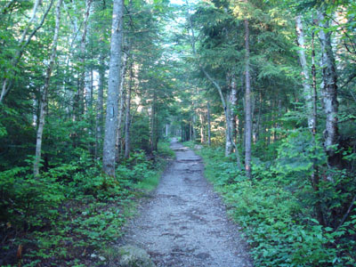
The Zealand Trail trailhead at the end of Zealand Road
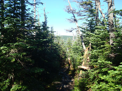
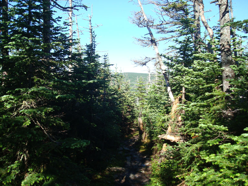
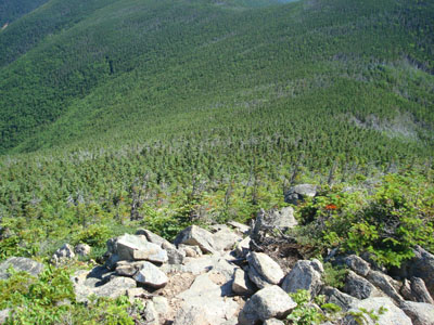
Other than this look down the Twinway Trail, there isn't much to see near the Zealand Mountain summit
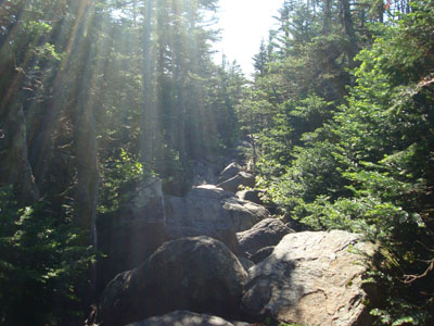
The Twinway between Zealand and Guyot has some rough footing in places
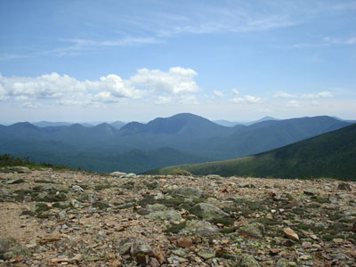
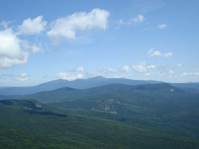
Looking east-southeast at Mt. Carrigain from the Mt. Guyot summit
<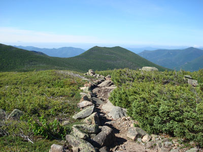
Heading down the Bondcliff Trail on the way to West Bond

Looking north at South Twin Mountain from the West Bond summit
<
Looking down the West Bond Trail on the way to Mt. Bond
Looking at Mount Washington from the Mt. Bond summit
<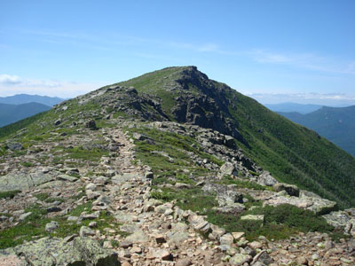
Looking up the Bondcliff Trail at Bondcliff
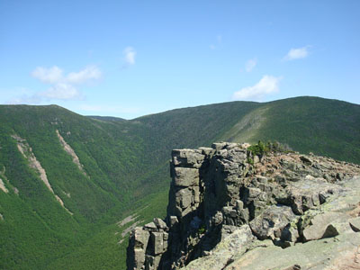
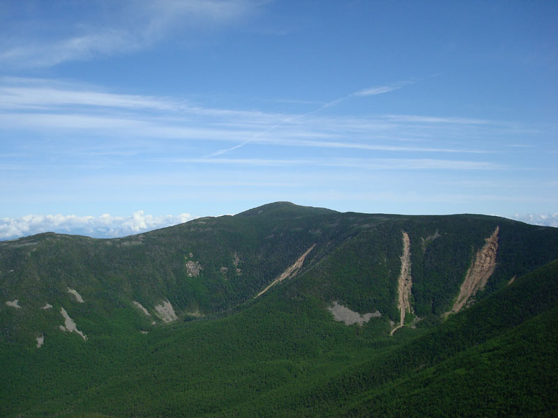
Looking at West Bond, the famous cliff, and Mt. Bond from the Bondcliff summit

Directions to trailhead: Take US 302 west from Bartlett past Bretton Woods Ski Area. A few minutes after, take a left onto Zealand Road. The Zealand WMNF fee parking area and Zealand Trail trailhead are located at the end of the road.
Back to Zealand Mountain Profile
Back to Mt. Guyot Profile
Back to Mt. Bond - West Peak Profile
Back to Mt. Bond Profile
Back to Bondcliff Profile
|