Home
States
Colorado
Connecticut
Maine
Massachusetts
New Hampshire
New York
Rhode Island
Utah
Vermont
View All
Lists
NE 4,000 Footers
NE 100 Highest
NH 4,000 Footers
NH 100 Highest
NH 52 With A View
NH Belknap Range
NH Ossipee 10
Links
Trail Conditions
Trip Log
Sunrises
Sunsets
About
|
Burnt Meadow Mountain
Brownfield, ME
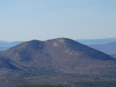
Burnt Meadow Mountain as seen from Mt. Cutler
 Summary Summary
Burnt Meadow Mountain is considered to be the northern peak in the Burnt Meadow Mountains range. Due to a fire years ago, significant portions of this mountain are bare. An alpine ski area once operated on the northern slope.
Summit Elevation
1,575 feet
Summit Facilities
None.
Trip Reports:
Click on the date for photos, timestamps, and maps.
| Date of Hike |
Trail(s) |
Length |
Steepness |
Vertical |
|
| May 24, 2021 |
Burnt Meadow Trail, more |
Moderate |
Very Difficult |
1,971' |
| September 22, 2010 |
Burnt Meadow Trail |
Moderate |
Very Difficult |
1,396' |
| September 18, 2009 |
Twin Brook Trail, more |
Moderate |
Difficult |
1,551' |
| December 28, 2008 |
Burnt Meadow Trail, more |
Moderate |
Very Difficult |
2,506' |
| August 14, 2007 |
Burnt Meadow Trail |
Moderate |
Very Difficult |
1,396' |
|
More Information
- Burnt Meadow Mountain - NewEnglandSkiHistory.com
- Burnt Meadow Mountain - New England Lost Ski Areas Project
|
