Home
States
Colorado
Connecticut
Maine
Massachusetts
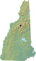
New Hampshire
New York
Rhode Island
Utah
Vermont
View All
Lists
NE 4,000 Footers
NE 100 Highest
NH 4,000 Footers
NH 100 Highest
NH 52 With A View
NH Belknap Range
NH Ossipee 10
Links
Trail Conditions
Trip Log
Sunrises
Sunsets
About
|
Middle Sugarloaf
Bethlehem, NH
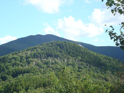
Middle Sugarloaf as seen from near the summit of North Sugarloaf
 Summary Summary
Middle Sugarloaf, located northwest of Mt. Hale, features views in nearly all directions from its ledgy summit. Winter access is more difficult due to the seasonal closure of Zealand Road.
Summit Elevation
2,539 feet
Summit Facilities
None.
Trails
Sugarloaf Trail
Trip Reports:
Click on the date for photos, timestamps, and maps.
| Date of Hike |
Trail(s) |
Length |
Steepness |
Vertical |
|
| October 18, 2018 |
Sugarloaf Trail, more |
Moderate |
Difficult |
1,215' |
| October 10, 2016 |
Sugarloaf Trail, more |
Moderate |
Difficult |
935' |
| April 1, 2015 |
Sugarloaf Trail, more |
Moderate |
Difficult |
1,159' |
| September 27, 2013 |
Sugarloaf Trail, more |
Moderate |
Difficult |
1,215' |
| June 18, 2013 |
Sugarloaf Trail, more |
Moderate |
Difficult |
1,215' |
| June 18, 2012 |
Sugarloaf Trail, more |
Moderate |
Difficult |
1,215' |
| October 29, 2011 |
Sugarloaf Trail, more |
Moderate |
Difficult |
1,215' |
| June 4, 2011 |
Sugarloaf Trail, more |
Moderate |
Difficult |
1,215' |
| August 14, 2008 |
Sugarloaf Trail, more |
Moderate |
Difficult |
1,205' |
|
More Information
|
