Home
States
Colorado
Connecticut
Maine
Massachusetts
New Hampshire
New York
Rhode Island
Utah
Vermont
View All
Lists
NE 4,000 Footers
NE 100 Highest
NH 4,000 Footers
NH 100 Highest
NH 52 With A View
NH Belknap Range
NH Ossipee 10
Links
Trail Conditions
Trip Log
Sunrises
Sunsets
About
|
Massachusetts Mountains & Peaks
Summary
Massachusetts is home to the Berkshires, a range covering much of the western portion of the state. Though one may consider Massachusetts hiking to be tame, many peaks in the Berkshires provide challenging treks with excellent views.
State High Point
Mt. Greylock in Adams at 3,491 feet.
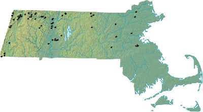
Map
View Google Map of peaks on this page.
Mountain Profiles
Click on the name of the mountain or peak for maps, photos, and more.
|
Western Massachusetts
 |
| Berkshire County |
| Berlin Mountain | Petersburg, NY | 2,798' |
| Berry Mountain | Hancock, MA | 2,203' |
| Borden Mountain | Savoy, MA | 2,505' |
| Brodie Mountain | New Ashford, MA | 2,613' |
| Clark Mountain | Florida, MA | 1,920' |
| Mt. Everett | Mount Washington, MA | 2,602' |
| Mt. Fitch | Adams, MA | 3,110' |
| Mt. Frissell | Mount Washington, MA | 2,453' |
| Mt. Greylock | Adams, MA | 3,491' |
| Monument Mountain | Great Barrington, MA | 1,750' |
| Pine Mountain | Hancock, MA | 2,220' |
| Mt. Race | Mount Washington, MA | 2,365' |
| Ragged Mountain | Adams, MA | 2,517' |
| Mt. Raimer | Petersburg, NY | 2,575' |
| Rounds Rock | Cheshire, MA | 2,581' |
| Saddle Ball Mountain | New Ashford, MA | 3,238' |
| Spruce Hill | Adams, MA | 2,566' |
| Squaw Peak | Great Barrington, MA | 1,642' |
| Stony Ledge | Williamstown, MA | 2,560' |
| Tower Mountain | Hancock, MA | 2,193' |
| Mt. Williams | North Adams, MA | 2,951' |
|
| Franklin County |
| Adams Mountain | Rowe, MA | 2,110' |
| Catamount Hill | Colrain, MA | 1,442' |
| Crag Mountain | Northfield, MA | 1,503' |
| Goodnow Hill | Buckland, MA | 1,233' |
| Mt. Grace | Warwick, MA | 1,617' |
| Greenfield Mountain | Shelburne, MA | 1,158' |
| High Ledge | Shelburne, MA | 1,268' |
| Mt. Institute | Hawley, MA | 1,538' |
| Little Mt. Grace | Warwick, MA | 1,225' |
| Massaemett Mountain | Shelburne, MA | 1,588' |
| Negus Mountain | Rowe, MA | 1,773' |
| North Sugarloaf Mountain | South Deerfield, MA | 791' |
| Pocumtuck Mountain | Charlemont, MA | 1,872' |
| Pocumtuck Rock | Deerfield, MA | 852' |
| Pony Mountain | Ashfield, MA | 1,420' |
| Roaring Mountain | Sunderland, MA | 1,195' |
| Rocky Mountain | Greenfield, MA | 495' |
| Sachem Head | Greenfield, MA | 452' |
| South Sugarloaf Mountain | South Deerfield, MA | 652' |
| Spruce Mountain | Monroe, MA | 2,730' |
| Mt. Toby | Sunderland, MA | 1,269' |
| Todd Mountain | Charlemont, MA | 1,711' |
| Todd Mountain | Rowe, MA | 1,920' |
|
| Hampden County |
|
|
| Hampshire County |
| Bare Mountain | Amherst, MA | 1,010' |
| Mt. Hitchcock | Hadley, MA | 1,010' |
| Mt. Holyoke | Hadley, MA | 940' |
| Mt. Lincoln | Pelham, MA | 1,238' |
| Moore Hill | Goshen, MA | 1,697' |
| Mt. Norwottock | Amherst, MA | 1,106' |
| Tinker Hill | Hadley, MA | 659' |
|
Central Massachusetts
 |
| Worcestor County |
| Mt. Hunger | Ashburnham, MA | 1,447' |
| Nutting Hill | Ashburnham, MA | 1,625' |
| Peppercorn Hill | Upton, MA | 585' |
| Mt. Pisgah | Northborough, MA | 715' |
| Wachusett Mountain | Princeton, MA | 2,006' |
| Mt. Watatic | Ashburnham, MA | 1,832' |
|
Eastern Massachusetts
 |
| Essex County |
|
|
| Middlesex County |
| Blood Hill | Ashby, MA | 1,515' |
| Jericho Hill | Marlborough, MA | 550' |
| Nashoba Hill | Westford, MA | 426' |
| Newtown Hill | Littleton, MA | 443' |
| Nobscot Hill | Framingham, MA | 602' |
| Oak Hill | Littleton, MA | 504' |
| Pine Hill | Medford, MA | 243' |
| Prospect Hill | Waltham, MA | 478' |
| Wenepoykin Hill | Medford, MA | 225' |
|
| Norfolk County |
|
|
|
