Home
States
Colorado
Connecticut
Maine
Massachusetts
New Hampshire
New York
Rhode Island
Utah
Vermont
View All
Lists
NE 4,000 Footers
NE 100 Highest
NH 4,000 Footers
NH 100 Highest
NH 52 With A View
NH Belknap Range
NH Ossipee 10
Links
Trail Conditions
Trip Log
Sunrises
Sunsets
About
|
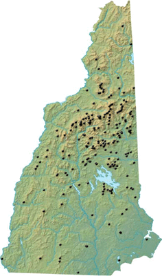
New Hampshire Mountains & Peaks
Summary
New Hampshire is home to the White Mountains and the legendary Presidential Range. While these are tremendous mountains, they shouldn't overshadow superb hikes located in other parts of the state, such as the Lakes Region.
The Appalachian Mountain Club has designated a list of 48 New Hampshire peaks as being part of a 4,000' club. As a result, these peaks are amongst the most heavily hiked peaks in the state.
While many of the peaks in New Hampshire require a challenging hike, some are accessible via other means, such as automobile road or aerial lift.
The most hiked peak in New Hampshire is Mt. Monadnock. Located in the southern portion of the state, Mt. Monadnock is amongst the most popular hikes in the world.
State High Point
Mt. Washington in Sargent's Purchase at 6,288 feet.
Mountain Profiles
Click on the name of the mountain or peak for maps, photos, and more.
|
| Northern New Hampshire |
Coos County
Highpoint: Mt. Washington at 6,288' |
| Mt. Adams | Thompson and Meserve's Purchase, NH | 5,774' |
| Adams 4 | Thompson and Meserve's Purchase, NH | 5,344' |
| North Bald Cap | Success, NH | 2,893' |
| Bald Mountain | Stark, NH | 2,378' |
| North Baldface | Bean's Purchase, NH | 3,610' |
| Beech Hill | Carroll, NH | 2,267' |
| Black Mountain (Northwest Peak) | Wentworths Location, NH | 2,944' |
| Mt. Blue | Columbia, NH | 3,723' |
| Mt. Blue - North Peak | Columbia, NH | 3,190' |
| Boott Spur | Sargent's Purchase, NH | 5,500' |
| Boy Mountain | Jefferson, NH | 2,234' |
| The Bulge | Kilkenny, NH | 3,950' |
| Bunnell Mountain | Columbia, NH | 3,723' |
| Mt. Cabot | Kilkenny, NH | 4,170' |
| Mt. Cabot | Shelburne, NH | 1,512' |
| Cape Horn | Northumberland, NH | 2,060' |
| Cape Horn - East Peak | Northumberland, NH | 1,790' |
| Carter Dome | Bean's Purchase, NH | 4,832' |
| Middle Carter Mountain | Bean's Purchase, NH | 4,610' |
| North Carter Mountain | Bean's Purchase, NH | 4,530' |
| South Carter Mountain | Bean's Purchase, NH | 4,430' |
| Cascade Mountain | Shelburne, NH | 2,630' |
| Castle Mountain | Stratford, NH | 3,567' |
| Castle Mountain (West Peak) | Stratford, NH | 3,590' |
| Mt. Clay | Thompson and Meserve's Purchase, NH | 5,533' |
| Mt. Clinton | Bean's Grant, NH | 4,310' |
| Mt. Crag | Shelburne, NH | 1,412' |
| Mt. Crawford | Hadley's Purchase, NH | 3,119' |
| Mt. Crescent | Randolph, NH | 3,251' |
| Crows Nest | Shelburne, NH | 1,287' |
| Crystal Mountain (Southwest Peak) | Dix's Grant, NH | 2,970' |
| Currier Mountain | Low and Burbanks Grant, NH | 2,790' |
| Mt. Dartmouth | Low and Burbanks Grant, NH | 3,727' |
| Mt. Davis | Sargent's Purchase, NH | 3,819' |
| Dead Water Ridge - Southeast Peak | Stewartstown, NH | 2,659' |
| Mt. Deception | Low and Burbanks Grant, NH | 3,671' |
| Devils Slide | Stark, NH | 1,590' |
| Diamond Peaks | Second College Grant, NH | 2,050' |
| Dixville Peak | Dixville, NH | 3,470' |
| Eagle Crag | Bean's Purchase, NH | 3,020' |
| Mt. Eisenhower | Chandler's Purchase, NH | 4,780' |
| Mt. Forest | Berlin, NH | 2,068' |
| Mt. Franklin | Sargent's Purchase, NH | 5,004' |
| Goback Mountain | Stratford, NH | 3,485' |
| Gore Mountain | Stratford, NH | 3,610' |
| Gulf Peak | Sargent's Purchase, NH | 4,806' |
| Mt. Hayes | Shelburne, NH | 2,555' |
| Mt. Hight | Bean's Purchase, NH | 4,675' |
| Mt. Hope | Hadley's Purchase, NH | 2,505' |
| The Horn | Kilkenny, NH | 3,905' |
| Howe Peak | Shelburne, NH | 2,966' |
| Hutchins Mountain | Stark, NH | 3,730' |
| Imp Face | Bean's Purchase, NH | 3,165' |
| Mt. Ingalls | Shelburne, NH | 2,242' |
| Mt. Isolation | Sargent's Purchase, NH | 4,004' |
| Mt. Isolation (North Peak) | Cutts Grant, NH | 4,293' |
| Mt. Jackson | Bean's Grant, NH | 4,052' |
| Mt. Jefferson | Thompson and Meserve's Purchase, NH | 5,712' |
| Mt. Lethe | Bean's Purchase, NH | 4,584' |
| Long Mountain - Middle Peak | Odell, NH | 3,661' |
| Long Mountain - West Peak | Odell, NH | 3,661' |
| Lowes Bald Spot | Sargent's Purchase, NH | 2,875' |
| Milan Hill | Milan, NH | 1,737' |
| Mt. Madison | Low and Burbank's Grant, NH | 5,367' |
| Magalloway Mountain | Pittsburg, NH | 3,384' |
| Mt. Martha | Carroll, NH | 3,573' |
| Mt. Mary | Stark, NH | 3,570' |
| Mt. Meader | Bean's Purchase, NH | 2,782' |
| Middle Mountain | Shelburne, NH | 2,009' |
| Mill Mountain | Stark, NH | 2,517' |
| Millen Hill | Chandler's Purchase, NH | 3,355' |
| Millsfield Mountain | Millsfield, NH | 2,889' |
| Mt. Monroe | Sargent's Purchase, NH | 5,372' |
| Mt. Moriah | Bean's Purchase, NH | 4,049' |
| Mt. Muise | Odell, NH | 3,615' |
| Notch Mountain | Stratford, NH | 3,402' |
| Owlshead | Carroll, NH | 3,258' |
| North Percy Peak | Stratford, NH | 3,430' |
| South Percy Peak | Stratford, NH | 3,234' |
| Mt. Pierce | Bean's Grant, NH | 4,310' |
| Pilot Range (Middle Peak) | Stark, NH | 3,615' |
| Pilot Range (West Peak) | Stark, NH | 3,530' |
| Pine Mountain | Gorham, NH | 2,405' |
| Pliny Mountain | Kilkenny, NH | 3,605' |
| Prospect Mountain | Pittsburg, NH | 2,734' |
| Prospect Mountain | Lancaster, NH | 2,077' |
| Mt. Quincy Adams | Thompson and Meserve's Purchase, NH | 5,410' |
| Mt. Randolph | Randolph, NH | 3,081' |
| Mt. Reagan | Thompson and Meserve's Purchase, NH | 5,533' |
| Mt. Resolution | Sargent's Purchase, NH | 3,415' |
| Rogers Ledge | Kilkenny, NH | 2,965' |
| West Royce Mountain | Bean's Purchase, NH | 3,210' |
| Mt. Sam Adams | Low and Burbanks Grant, NH | 5,585' |
| Savage Mountain | Stratford, NH | 3,510' |
| East Savage Mountain | Stratford, NH | 2,850' |
| Shelburne Moriah Mountain | Shelburne, NH | 3,735' |
| Slide Peak | Sargent's Purchase, NH | 4,806' |
| East Spruce Mountain | Stratford, NH | 3,010' |
| Stairs Mountain | Sargent's Purchase, NH | 3,463' |
| Mt. Starr King | Jefferson, NH | 3,907' |
| Stub Hill | Pittsburg, NH | 3,627' |
| North Stub Hill | Pittsburg, NH | 3,422' |
| Mt. Success | Success, NH | 3,565' |
| Sugar Hill | Stewartstown, NH | 2,985' |
| Sugarloaf | Stratford, NH | 3,710' |
| Mt. Surprise | Shelburne, NH | 2,194' |
| Table Rock | Dixville, NH | 2,510' |
| Teapot Mountain | Stratford, NH | 3,390' |
| Terrace Mountain | Kilkenny, NH | 3,655' |
| Terrace Mountain (North Peak) | Kilkenny, NH | 3,630' |
| Tumble Dick Mountain | Dixville, NH | 2,907' |
| Unknown Pond Peak | Kilkenny, NH | 3,510' |
| Victor Head | Stark, NH | 2,265' |
| Mt. Washington | Sargent's Purchase, NH | 6,288' |
| Mt. Waumbek | Kilkenny, NH | 4,006' |
| Mt. Webster | Bean's Grant, NH | 3,910' |
| Mt. Weeks | Berlin, NH | 3,901' |
| Mt. Weeks (Middle Peak) | Berlin, NH | 3,684' |
| Mt. Weeks (South Peak) | Randolph, NH | 3,885' |
| Whitcomb Mountain (East Peak) | Millsfield, NH | 2,510' |
| Wildcat A | Bean's Grant, NH | 4,422' |
| Wildcat B | Bean's Grant, NH | 4,305' |
| Wildcat C | Bean's Grant, NH | 4,285' |
| Wildcat D | Bean's Grant, NH | 4,062' |
| Wildcat E | Bean's Grant, NH | 4,046' |
|
| Middle New Hampshire |
Belknap County
Highpoint: Belknap Mountain at 2,382' |
| Mt. Anna | Gilmanton, NH | 1,670' |
| Avery Hill | Alton, NH | 1,461' |
| Bald Ledge | New Hampton, NH | 1,130' |
| Bean Hill | Northfield, NH | 1,510' |
| Beech Hill | New Hampton, NH | 1,490' |
| Belknap Mountain | Gilford, NH | 2,382' |
| Burleigh Mountain | New Hampton, NH | 1,462' |
| Cedar Mountain | Alton, NH | 1,082' |
| Cobble Mountain | Gilford, NH | 1,403' |
| Durrell Mountain | Gilmanton, NH | 1,650' |
| Goat Pasture Hill | Alton, NH | 1,130' |
| Grant Hill | Gilmanton, NH | 1,550' |
| Gunstock Mountain | Gilford, NH | 2,245' |
| Harper Hill | New Hampton, NH | 1,210' |
| Heator Mountain | Gilford, NH | 1,808' |
| Hersey Mountain | Sanbornton, NH | 2,001' |
| Mt. Klem | Gilford, NH | 2,001' |
| Ladd Mountain | Meredith, NH | 1,330' |
| Locke's Hill | Gilford, NH | 1,057' |
| Mt. Mack | Gilford, NH | 1,945' |
| Mt. Major | Alton, NH | 1,786' |
| Pine Mountain | Alton, NH | 1,410' |
| Piper Mountain | Gilford, NH | 2,044' |
| East Quarry Mountain | Alton, NH | 1,890' |
| West Quarry Mountain | Alton, NH | 1,894' |
| Rand Mountain | Gilford, NH | 1,883' |
| Mt. Rowe | Gilford, NH | 1,680' |
| Saddle Hill | Meredith, NH | 1,310' |
| Sanbornton Mountain | Sanbornton, NH | 1,607' |
| Mt. Shannon | Gilmanton, NH | 1,265' |
| Straightback Mountain | Alton, NH | 1,890' |
| North Straightback Mountain | Alton, NH | 1,910' |
| Swett Mountain | Gilmanton, NH | 1,535' |
| Whiteface Mountain | Gilford, NH | 1,664' |
|
Carroll County
Highpoint: Side of Sandwich Dome at 3,960' |
| Bald Knob | Moultonborough, NH | 1,801' |
| Bald Ledge | Madison, NH | 1,183' |
| Bald Mountain | Albany, NH | 2,140' |
| Bald Mountain | Tamworth, NH | 2,450' |
| Baldface Knob | Chatham, NH | 3,025' |
| South Baldface | Chatham, NH | 3,570' |
| Bartlett Haystack | Bartlett, NH | 2,995' |
| Bartlett Haystack - Northeast Peak | Bartlett, NH | 2,620' |
| Bartlett Mountain | Bartlett, NH | 2,661' |
| Bayle Mountain | Ossipee, NH | 1,853' |
| Bear Mountain | Bartlett, NH | 3,220' |
| Big Attitash Mountain | Bartlett, NH | 2,910' |
| Little Attitash Mountain | Bartlett, NH | 2,518' |
| Big Ball Mountain | Tuftonboro, NH | 2,060' |
| Black Cap | Conway, NH | 2,369' |
| Black Mountain | Sandwich, NH | 2,732' |
| Black Mountain | Jackson, NH | 3,304' |
| Black Mountain (Middle Peak) | Jackson, NH | 2,757' |
| Black Snoot | Tuftonboro, NH | 2,803' |
| Black Snout | Tamworth, NH | 2,689' |
| Brier Hill | Tuftonboro, NH | 1,319' |
| Canaan Mountain | Tuftonboro, NH | 2,072' |
| Carter Ledge | Albany, NH | 2,420' |
| Cathedral Ledge | Bartlett, NH | 1,159' |
| Mount Chocorua | Albany, NH | 3,474' |
| Copple Crown Mountain | Brookfield, NH | 1,868' |
| Cranmore Mountain | Conway, NH | 1,667' |
| Dinsmore Mountain | Sandwich, NH | 2,303' |
| East Doublehead Mountain | Sandwich, NH | 2,158' |
| Doublehead Mountain - North Peak | Sandwich, NH | 2,020' |
| North Doublehead | Jackson, NH | 3,053' |
| South Doublehead | Jackson, NH | 2,939' |
| West Doublehead Mountain | Sandwich, NH | 2,130' |
| Duck's Head | Jackson, NH | 1,311' |
| Dundee Hill | Conway, NH | 1,421' |
| Durgin Hill | Freedom, NH | 1,466' |
| Eagle Cliff | Sandwich, NH | 1,270' |
| Eagle Mountain | Jackson, NH | 1,613' |
| Eastman Mountain | Chatham, NH | 2,939' |
| Faraway Mountain | Moultonborough, NH | 2,782' |
| Mt. Flagg | Tuftonboro, NH | 2,390' |
| Foss Mountain | Eaton, NH | 1,657' |
| Frankenstein Cliff | Hart's Location, NH | 2,451' |
| Grant Peak | West Ossipee, NH | 1,783' |
| Great Hill | Tamworth, NH | 1,270' |
| Green Mountain | Effingham, NH | 1,907' |
| Hanson Top | Effingham, NH | 1,826' |
| Hedgehog Mountain | Albany, NH | 2,532' |
| Hurricane Mountain | Conway, NH | 2,112' |
| Iron Mountain | Bartlett, NH | 2,726' |
| Mt. Israel | Sandwich, NH | 2,630' |
| Mt. Katherine | Sandwich, NH | 1,400' |
| Kearsarge North Mountain | Chatham, NH | 3,268' |
| King Pine | Madison, NH | 760' |
| Mt. Langdon | Bartlett, NH | 2,390' |
| Larcom Mountain | Tamworth, NH | 2,093' |
| Little Ball Mountain | Tuftonboro, NH | 1,710' |
| Little Larcom Mountain | Tamworth, NH | 1,685' |
| Mary's Mountain | Freedom, NH | 944' |
| Mt. Mexico | Tamworth, NH | 2,020' |
| Middle Mountain | Conway, NH | 1,857' |
| Middle Sister | Albany, NH | 3,340' |
| Middle Moat Mountain | Bartlett, NH | 2,805' |
| North Moat Mountain | Bartlett, NH | 3,196' |
| South Moat Mountain | Albany, NH | 2,770' |
| Moose Mountain | Brookfield, NH | 1,749' |
| Nickerson Ledge | Albany, NH | 1,670' |
| Nickerson Mountain | West Ossipee, NH | 1,700' |
| Oak Hill | Tuftonboro, NH | 1,180' |
| Owl's Cliff | Bartlett, NH | 2,940' |
| Page Hill | Tamworth, NH | 1,145' |
| Mt. Parker | Bartlett, NH | 3,004' |
| Mt. Paugus | Albany, NH | 3,198' |
| Mt. Paugus (South Peak) | Albany, NH | 3,100' |
| Peaked Mountain | Conway, NH | 1,739' |
| Mt. Pickering | Bartlett, NH | 1,930' |
| Prospect Mountain | Freedom, NH | 1,482' |
| Rattlesnake Mountain | Conway, NH | 1,590' |
| Red Hill | Moultonborough, NH | 2,033' |
| Rickers Knoll | Chatham, NH | 2,477' |
| Mt. Roberts | Moultonborough, NH | 2,582' |
| Sable Mountain | Chatham, NH | 3,519' |
| Mt. Shaw | Tuftonboro, NH | 2,990' |
| Mt. Shaw | Chatham, NH | 2,585' |
| Sentinel Mountain | Tuftonboro, NH | 1,680' |
| Mt. Squam | Sandwich, NH | 2,223' |
| Square Ledge | Albany, NH | 2,620' |
| Stacy Mountain | Madison, NH | 1,408' |
| Mt. Stanton | Bartlett, NH | 1,716' |
| Table Mountain | Bartlett, NH | 2,675' |
| Tate Mountain | Tuftonboro, NH | 2,060' |
| Thorn Mountain | Jackson, NH | 2,282' |
| Tin Mountain | Jackson, NH | 2,031' |
| Mt. Tremont | Bartlett, NH | 3,371' |
| The Twins (North Peak) | Chatham, NH | 2,519' |
| The Twins (South Peak) | Chatham, NH | 2,490' |
| Tumbledown Dick Mountain | Brookfield, NH | 1,147' |
| Turtleback Mountain | Moultonborough, NH | 2,203' |
| White Horse Ledge | Hale's Location, NH | 1,440' |
| White Ledge | Albany, NH | 2,010' |
| Whiteface Mountain | Wolfeboro, NH | 1,339' |
| Mt. Whittier | Tamworth, NH | 2,230' |
| Whitton Ledge | Albany, NH | 1,220' |
| Mt. Willard | Hart's Location, NH | 2,850' |
|
Grafton County
Highpoint: Mt. Lafayette at 5,260' |
| Acorn Hill | Lyme, NH | 1,377' |
| Acteon Ridge (Middle Peak) | Waterville Valley, NH | 2,489' |
| Mt. Agassiz | Bethlehem, NH | 2,378' |
| Ames Mountain | Wentworth, NH | 2,070' |
| Mt. Anderson | Livermore, NH | 3,740' |
| Mt. Avalon | Bethlehem, NH | 3,442' |
| Balch Hill | Hanover, NH | 956' |
| Bald Knob | Waterville Valley, NH | 2,300' |
| Bald Knob | Groton, NH | 2,050' |
| Bald Mountain | Franconia, NH | 2,340' |
| Bald Mountain | Campton, NH | 2,204' |
| Bald Peak | Easton, NH | 2,470' |
| Banks Pinnacle | Grafton, NH | 1,564' |
| Barber Mountain | Orange, NH | 2,166' |
| Barron Mountain | Thornton, NH | 1,660' |
| Bear Mountain | Hebron, NH | 1,847' |
| Mt. Bemis | Livermore, NH | 3,725' |
| Big Bickford Mountain | Franconia, NH | 3,261' |
| Black Mountain | Benton, NH | 2,830' |
| Blake Mountain | Thornton, NH | 1,561' |
| Mt. Blue | Benton, NH | 4,529' |
| Blue Ridge (Middle Peak) | Woodstock, NH | 2,740' |
| Blue Ridge (North Peak) | Woodstock, NH | 3,009' |
| Blueberry Mountain | Benton, NH | 2,662' |
| Mt. Bond | Lincoln, NH | 4,698' |
| Mt. Bond (West Peak) | Lincoln, NH | 4,540' |
| Bondcliff | Lincoln, NH | 4,265' |
| Brown Mountain | Alexandria, NH | 2,270' |
| Campton Mountain | Campton, NH | 2,387' |
| Cannon Mountain | Franconia, NH | 4,100' |
| Northeast Cannon Ball | Lincoln, NH | 3,769' |
| The Captain | Livermore, NH | 3,540' |
| Mt. Cardigan | Orange, NH | 3,155' |
| Carr Mountain | Wentworth, NH | 3,453' |
| Mt. Carrigain | Livermore, NH | 4,700' |
| Church Mountain | Alexandria, NH | 2,270' |
| Mt. Clough | Benton, NH | 3,561' |
| Colburn Hill | Lebanon, NH | 933' |
| Cone Mountain | Thornton, NH | 2,132' |
| Cooley Hill | Easton, NH | 2,485' |
| Cotton Mountain | Holderness, NH | 1,270' |
| Crane Mountain | Orange, NH | 2,423' |
| Mt. Crosby | Groton, NH | 2,230' |
| Mt. Cube | Orford, NH | 2,909' |
| Currier Hill | Wentworth, NH | 1,958' |
| Dickey Mountain | Waterville Valley, NH | 2,734' |
| Downing Mountain | Ellsworth, NH | 2,091' |
| Duck Pond Mountain | Livermore, NH | 3,340' |
| Eagle Cliff | Franconia, NH | 3,420' |
| Eustis Hill | Littleton, NH | 1,373' |
| Farnum Hill | Lebanon, NH | 1,336' |
| Farnum Hill (North Peak) | Lebanon, NH | 1,230' |
| Mt. Field | Bethlehem, NH | 4,340' |
| Mt. Field (West Peak) | Bethlehem, NH | 3,691' |
| Firescrew | Orange, NH | 3,064' |
| Fisher Mountain | Waterville Valley, NH | 2,609' |
| Fletcher Mountain | Groton, NH | 2,130' |
| Mt. Flume | Lincoln, NH | 4,328' |
| The Fool Killer | Waterville Valley, NH | 3,548' |
| Forbes Mountain | Alexandria, NH | 2,183' |
| Foss Mountain | Waterville Valley, NH | 3,312' |
| Galehead Mountain | Franconia, NH | 4,024' |
| Mt. Garfield | Franconia, NH | 4,500' |
| Garfield Ridge (East Peak) | Franconia, NH | 3,590' |
| Garfield Ridge (West Peak) | Franconia, NH | 3,667' |
| Green Mountain | Waterville Valley, NH | 3,540' |
| Green Peak | Waterville Valley, NH | 2,862' |
| Mt. Guyot | Lincoln, NH | 4,580' |
| Mt. Hale | Bethlehem, NH | 4,054' |
| Mt. Hale (South Peak) | Bethlehem, NH | 3,700' |
| Mt. Hancock (North Peak) | Lincoln, NH | 4,420' |
| Mt. Hancock (South Peak) | Lincoln, NH | 4,319' |
| Hibbard Mountain | Waterville Valley, NH | 2,940' |
| Mt. Hitchcock | Lincoln, NH | 3,620' |
| Mt. Hitchcock (South Peak) | Lincoln, NH | 3,500' |
| Holts Ledge | Lyme, NH | 2,110' |
| Hoyt Hill | Orange, NH | 2,034' |
| Mt. Huntington | Lincoln, NH | 3,700' |
| Mt. Huntington (South Peak) | Lincoln, NH | 3,700' |
| Huntington Hill | Hanover, NH | 1,270' |
| Jennings Peak | Waterville Valley, NH | 3,460' |
| Mt. Jim | Woodstock, NH | 4,172' |
| Mt. Kancamagus | Livermore, NH | 3,763' |
| Mt. Kineo | Ellsworth, NH | 3,313' |
| Kinsman Mountain (North Peak) | Lincoln, NH | 4,293' |
| Kinsman Mountain (South Peak) | Lincoln, NH | 4,358' |
| Mt. Lafayette | Franconia, NH | 5,260' |
| Mt. Lafayette (North Peak) | Franconia, NH | 5,060' |
| Mt. Liberty | Lincoln, NH | 4,459' |
| Mt. Lincoln | Franconia, NH | 5,089' |
| Little Haystack Mountain | Franconia, NH | 4,780' |
| Mt. Livermore | Holderness, NH | 1,500' |
| Loon Mountain (North Peak) | Lincoln, NH | 3,065' |
| Mt. Lowell | Livermore, NH | 3,740' |
| Melvin Mountain | Orange, NH | 2,177' |
| Mt. Mist | Warren, NH | 2,230' |
| Mittersill Peak | Franconia, NH | 3,617' |
| Moose Mountain (North Peak) | Hanover, NH | 2,300' |
| Moose Mountain (South Peak) | Hanover, NH | 2,290' |
| Mt. Moosilauke | Benton, NH | 4,802' |
| Mt. Moosilauke (South Peak) | Benton, NH | 4,523' |
| Mt. Morgan | Campton, NH | 2,220' |
| Mowglis Mountain | Alexandria, NH | 2,370' |
| Nanamocomuck Peak | Waterville Valley, NH | 3,340' |
| Mt. Nancy | Livermore, NH | 3,926' |
| Noon Peak | Waterville Valley, NH | 2,976' |
| The Nubble | Bethlehem, NH | 2,713' |
| Orange Mountain | Orange, NH | 2,684' |
| Ore Hill | Warren, NH | 1,680' |
| Oregon Mountain | Alexandria, NH | 2,239' |
| Mt. Oscar | Bethlehem, NH | 2,748' |
| Mt. Osceola | Livermore, NH | 4,340' |
| Mt. Osceola (East Peak) | Livermore, NH | 4,156' |
| Mt. Osceola (Middle Peak) | Livermore, NH | 4,220' |
| Owl's Head | Franconia, NH | 4,025' |
| Mt. Passaconaway | Waterville Valley, NH | 4,043' |
| Peak Above The Nubble | Bethlehem, NH | 3,813' |
| Peaked Hill | Bridgewater, NH | 1,905' |
| Peaked Mountain | Piermont, NH | 1,568' |
| Mt. Pemigewasset | Lincoln, NH | 2,557' |
| Mt. Percival | Campton, NH | 2,212' |
| Piermont Mountain | Piermont, NH | 2,717' |
| Pinnacle | Canaan, NH | 1,450' |
| Plymouth Mountain | Plymouth, NH | 2,193' |
| Potash Mountain | Waterville Valley, NH | 2,680' |
| Mt. Prospect | Holderness, NH | 2,064' |
| Rattlesnake Mountain | Rumney, NH | 1,594' |
| East Rattlesnake | Sandwich, NH | 1,289' |
| West Rattlesnake | Holderness, NH | 1,240' |
| Mt. Rosebrook | Bethlehem, NH | 3,004' |
| Roundtop | Bristol, NH | 1,110' |
| Little Roundtop | Bristol, NH | 1,010' |
| Russell Crag | Woodstock, NH | 1,640' |
| Sachem Peak | Waterville Valley, NH | 2,860' |
| Sandwich Mountain | Waterville Valley, NH | 3,980' |
| Sawtooth | Campton, NH | 2,280' |
| Sayre Peak | Woodstock, NH | 3,157' |
| Scar Ridge | Lincoln, NH | 3,774' |
| Scar Ridge (East Peak) | Lincoln, NH | 3,610' |
| Scar Ridge (Middle Peak) | Lincoln, NH | 3,500' |
| Scarface Mountain | Franconia, NH | 2,802' |
| Scaur Peak | Waterville Valley, NH | 3,605' |
| Signal Hill | Lebanon, NH | 1,299' |
| East Sleeper | Waterville Valley, NH | 3,850' |
| West Sleeper | Waterville Valley, NH | 3,881' |
| Smarts Mountain | Lyme, NH | 3,238' |
| Stinson Mountain | Rumney, NH | 2,900' |
| Sugarloaf | Alexandria, NH | 1,370' |
| Little Sugarloaf | Alexandria, NH | 1,002' |
| Middle Sugarloaf | Bethlehem, NH | 2,539' |
| North Sugarloaf | Bethlehem, NH | 2,310' |
| Sunday Mountain | Orford, NH | 1,823' |
| Mt. Tecumseh | Waterville Valley, NH | 4,003' |
| Mt. Tecumseh (Northwest Peak) | Waterville Valley, NH | 3,156' |
| Mt. Tecumseh (West Peak) | Waterville Valley, NH | 3,766' |
| Tenney Mountain | Groton, NH | 2,350' |
| Mt. Tom | Bethlehem, NH | 4,051' |
| Mt. Tripyramid (Middle Peak) | Waterville Valley, NH | 4,140' |
| Mt. Tripyramid (North Peak) | Waterville Valley, NH | 4,180' |
| Mt. Tripyramid (South Peak) | Waterville Valley, NH | 4,080' |
| Mt. Truman | Franconia, NH | 5,000' |
| North Twin Mountain | Franconia, NH | 4,761' |
| South Twin Mountain | Franconia, NH | 4,902' |
| Vose Spur | Livermore, NH | 3,862' |
| Mt. Webster | Holderness, NH | 2,076' |
| Webster Slide Mountain | Warren, NH | 2,184' |
| Welch Mountain | Waterville Valley, NH | 2,605' |
| Mt. Weetamoo | Campton, NH | 2,548' |
| Whaleback Mountain | Lincoln, NH | 3,586' |
| Whaleback Mountain (South Peak) | Lincoln, NH | 3,060' |
| Whites Pinnacle | Haverhill, NH | 1,470' |
| Mt. Whiteface | Waterville Valley, NH | 4,020' |
| Whitewall Mountain | Bethlehem, NH | 3,405' |
| Whitten Woods - North Peak | Ashland, NH | 1,173' |
| Whitten Woods - South Peak | Ashland, NH | 1,136' |
| Mt. Willey | Bethlehem, NH | 4,285' |
| Mt. Wolf | Lincoln, NH | 3,500' |
| Wonalancet Hedgehog | Waterville Valley, NH | 3,140' |
| Mt. Wonalancet | Waterville Valley, NH | 2,780' |
| Zealand Mountain | Lincoln, NH | 4,260' |
|
| Southern New Hampshire |
Cheshire County
Highpoint: Monadnock Mountain at 3,165' |
| Bacon Ledge | Stoddard, NH | 1,960' |
| Bald Hill | Marlow, NH | 1,625' |
| Beech Hill | Keene, NH | 1,050' |
| Daniels Mountain | Hinsdale, NH | 1,230' |
| East Hill | Chesterfield, NH | 1,098' |
| Gap Mountain (North Peak) | Troy, NH | 1,840' |
| Gap Mountain (South Peak) | Troy, NH | 1,900' |
| Hubbard Hill | Stoddard, NH | 1,896' |
| Jackson Hill | Stoddard, NH | 2,061' |
| Mt. Kilburn | Walpole, NH | 1,120' |
| Monadnock Mountain | Jaffrey, NH | 3,165' |
| Pitcher Mountain | Stoddard, NH | 2,153' |
| Round Mountain | Stoddard, NH | 1,950' |
| Wantastiquet Mountain | Chesterfield, NH | 1,351' |
|
Hillsborough County
Highpoint: Pack Monadnock Mountain at 2,290' |
|
|
| Bald Mountain | Antrim, NH | 2,037' |
| Clark Summit | Deering, NH | 1,570' |
| Crotched Mountain | Francestown, NH | 2,066' |
| Hedgehog Hill (North Peak) | Deering, NH | 1,322' |
| Joe English Hill | New Boston, NH | 1,285' |
| Lyndeborough Mountain | Lyndeborough, NH | 1,650' |
| Pack Monadnock Mountain | Peterborough, NH | 2,290' |
| North Pack Monadnock Mountain | Greenfield, NH | 2,276' |
| The Pinnacle | Lyndeborough, NH | 1,703' |
| Potanipo Hill | Brookline, NH | 613' |
| Pratt Mountain | New Ipswitch, NH | 1,817' |
| Rose Mountain | Lyndeborough, NH | 1,730' |
| Skatutakee Mountain | Hancock, NH | 1,998' |
| Temple Mountain (Burton Peak) | Temple, NH | 2,010' |
| Temple Mountain (Holt Peak) | Temple, NH | 2,045' |
| Thumb Mountain | Hancock, NH | 1,978' |
| North Uncanoonuc Mountain | Goffstown, NH | 1,324' |
| South Uncanoonuc Mountain | Goffstown, NH | 1,315' |
| Wilson Hill | Deering, NH | 1,414' |
| Winn Mountain | Lyndeborough, NH | 1,686' |
| Wolf Hill | Deering, NH | 1,510' |
|
Merrimack County
Highpoint: Mt. Kearsarge at 2,937' |
| Bog Mountain | Wilmot, NH | 1,787' |
| Braley Hill | Danbury, NH | 2,170' |
| Catamount Hill | Allenstown, NH | 721' |
| Catamount Mountain | Pittsfield, NH | 1,331' |
| Craney Hill | Henniker, NH | 1,402' |
| Eagles Nest | Wilmot, NH | 1,473' |
| Fort Mountain | Epsom, NH | 1,413' |
| Great Hill | Bow, NH | 875' |
| Mt. Kearsarge | Warner, NH | 2,937' |
| Kings Hill | Sutton, NH | 1,930' |
| McCoy Mountain | Epsom, NH | 1,275' |
| Neville Peak | Epsom, NH | 1,191' |
| Oak Hill | Loudon, NH | 990' |
| The Pinnacle | Hooksett, NH | 485' |
| Ragged Mountain | Danbury, NH | 2,225' |
| Sunapee Mountain | Newbury, NH | 2,726' |
| Sunset Hill | Newbury, NH | 1,820' |
| Tinkham Hill | Danbury, NH | 2,330' |
| Tucker Mountain | Hill, NH | 1,644' |
|
Rockingham County
View Google Map
Highpoint: Nottingham Mountain at 1,345' |
|
| |
Strafford County
View Google Map
Highpoint: Side of Copple Crown Mountain at 1,700' |
|
|
| Blue Job Mountain | Farmington, NH | 1,357' |
| Caverly Mountain | New Durham, NH | 1,433' |
| Parker Mountain | Strafford, NH | 1,410' |
| Phoebes Nable Mountain | Middleton, NH | 1,185' |
| Piper Mountain | Middleton, NH | 976' |
| Teneriffe Mountain | Milton, NH | 1,090' |
|
Sullivan County
View Google Map
Highpoint: Croydon Peak at 2,756' |
|
| Bean Mountain | Lempster, NH | 2,326' |
| Flatrock Hill | Claremont, NH | 1,080' |
| Frenchs Ledge | Plainfield, NH | 1,370' |
| Green Mountain | Claremont, NH | 2,018' |
| Kennedy Hill | Lempster, NH | 2,159' |
| Lovewell Mountain | Washington, NH | 2,473' |
| Melvin Hill | Springfield, NH | 2,290' |
| Pitcher Hill | Springfield, NH | 1,630' |
| Silver Mountain | Lempster, NH | 2,160' |
| Snow Hill | Grantham, NH | 1,360' |
|
|
